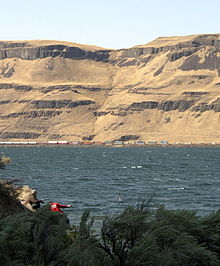
Wallula Gap
Contenu soumis à la licence CC-BY-SA. Source : Article Wallula Gap de Wikipédia en français (auteurs)
Regardez d'autres dictionnaires:
Wallula Gap — is a large water gap through basalt anticlines in the Columbia River Basin in the U.S. state of Washington, just south of the confluence of the Walla Walla and Columbia rivers. It has been recognized as a National Natural Landmark by the National … Wikipedia
Wallula (Washington) — Wallula Main Street Lage im County und in Washington … Deutsch Wikipedia
Wallula — Main Street Lage im County und in Washington … Deutsch Wikipedia
Olympic-Wallowa Lineament — Location of the Olympic Wallowa Lineament. Is the OWL an optical illusion? The Olympic Wallowa lineament (OWL) – first reported by cartographer Erwin Raisz in 1945 [1] on a relief map of the continental United States – is a physiographic feature… … Wikipedia
Lake Lewis — was a temporary lake in the Pacific Northwest region of North America, largely formed by the Missoula Floods in about the 14th millennium B.C.The restricted flow of waters [Flow was restricted by a hydraulic dam a restriction to the flow rate… … Wikipedia
Columbia River Basalt Group — The Columbia River Basalt Group (including the Steen and Picture Gorge basalts) extends over portions of five states. The Columbia River Basalt Group is a large igneous province that lies across parts of the Western United States . It is found in … Wikipedia
Steamboats of the Columbia River — This article concerns steamboats operating between Tri Cities, Washington and the Pacific Ocean. For boats on the river s upper reaches, see Steamboats of Columbia River, Wenatchee Reach and Steamboats of the Arrow Lakes. Many steamboats operated … Wikipedia
Missoula Floods — Glacial Lake Columbia (west) and Glacial Lake Missoula (east) are shown south of Cordilleran Ice Sheet. The areas inundated in the Columbia and Missoula floods are shown in red … Wikipedia
Columbia-Flutbasalt — Der Columbia Plateaubasalt umfasst Teile von drei Bundesstaaten Der Columbia Plateaubasalt ist ein ausgedehnter Flutbasalt in den USA, der Teile der Bundesstaaten Washington, Oregon und Idaho bedeckt. Während des späten Miozäns und frühen… … Deutsch Wikipedia
Walla Walla River — The Walla Walla River is a tributary of the Columbia River, joining the Columbia just above Wallula Gap in southeastern Washington in the United States. The river flows through Umatilla County, Oregon and Walla Walla County, Washington.… … Wikipedia

