Vištuk
- Vištuk
-
Vištuk (allemand : Wischteich )[4] est un village de Slovaquie situé dans la région de Bratislava.
Histoire
Première mention écrite du village en 1244.
Notes et références
Catégories :
- Village de Slovaquie
- Village et ville du district de Pezinok
Wikimedia Foundation.
2010.
Contenu soumis à la licence CC-BY-SA. Source : Article Vištuk de Wikipédia en français (auteurs)
Regardez d'autres dictionnaires:
Vištuk — Wappen Karte … Deutsch Wikipedia
Vištuk — is a village and municipality in western Slovakia in Pezinok District in the Bratislava region. The town is located north of Senec and east of Modra.HistoryArcheologists found remains of settlements from roughly 5000 BC. The modern history of the … Wikipedia
Bratislava Region — Geobox | Region name = Bratislava other name = category = Region image caption = image caption = symbol = etymology = official name = motto = nickname = country = Slovakia country state = region = district = commune = municipality = border = part … Wikipedia
Modra — Coordinates: 48°19′54″N 17°18′32″E / 48.33167°N 17.30889°E / 48.33167; 17.30889 … Wikipedia
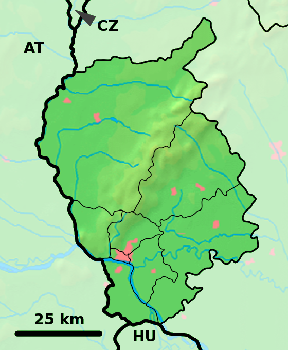
Pezinok District — Infobox Slovak district subject name = Pezinok District region district slovak region = Bratislava Region population = 54,164 (2001) prefix = ? area = 375.53 car plate = PK image location = Okres pezinok.png Pezinok District ( okres Pezinok ) is… … Wikipedia
List of municipalities and towns in Slovakia — Slovakia This is a comprehensive list of municipalities and towns in Slovakia. For lists of towns and municipalities sorted by Regions see the individual articles on Regions. For an outdated list of towns only in Slovakia see also List of towns… … Wikipedia
Doľany, Pezinok District — Pezinok District in the Bratislava region Doľany (Hungarian: Ottóvölgy) is a village and municipality in western Slovakia in Pezinok District in the Bratislava region. External links … Wikipedia
Dubová, Pezinok District — Pezinok District in the Bratislava region Dubová (Hungarian: Cserfalu) is a village and municipality in western Slovakia in Pezinok District in the Bratislava region. External links … Wikipedia
Bahon — Báhoň Wappen Karte … Deutsch Wikipedia
Budmerice — Wappen Karte … Deutsch Wikipedia
 Slovaquie
 Vištuk