Torridon Hills
Contenu soumis à la licence CC-BY-SA. Source : Article Torridon Hills de Wikipédia en français (auteurs)
Regardez d'autres dictionnaires:
Torridon Hills — The Torridon Hills surround Torridon village in the Northwest Highlands of Scotland. The name is usually applied to the mountains to the north of Glen Torridon.These are all made of a type of sandstone, known as Torridonian sandstone (see Geology … Wikipedia
Torridon — (Scottish Gaelic: Toirbheartan ) is a small village in the Northwest Highlands of Scotland. However the name is also applied to the area surrounding the village, particularly the Torridon Hills, mountains to the north of Glen Torridon.Torridon is … Wikipedia
Loch Torridon — tal como se ve desde el pueblo de Torridon. Loch Torridon (en gaélico escocés, Loch Thoirbheartan) es un loch de mar, un fiordo en la costa occidental de Escocia (Reino Unido) en las Tierras Altas noroccidentales. El pueblo de Torridon queda en… … Wikipedia Español
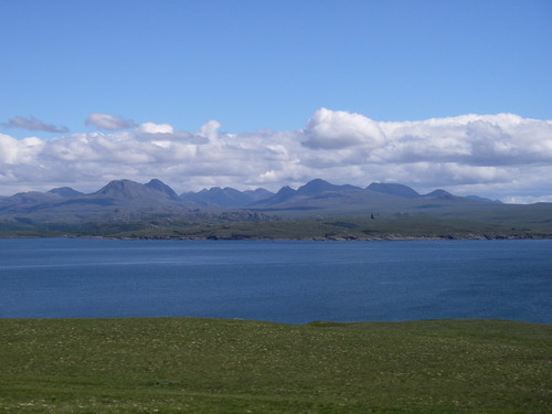
Loch Torridon — (Scottish Gaelic: Loch Thoirbheartan ) is a sea loch on the west coast of Scotland in the Northwest Highlands. Torridon village lies at the head of the loch and is surrounded by the spectacular Torridon Hills.The loch is a glacial sea loch around … Wikipedia
Mountains and hills of Scotland — Scotland is the most mountainous country in the United Kingdom. The area north and west of the Highland Boundary Fault is known as the Highlands, and contains the country s main mountain ranges. Scotland s mountain ranges, in a rough north to… … Wikipedia
List of mountains and hills of the United Kingdom — This is a links page to the hills and mountains to be found in the United Kingdom (England, Northern Ireland, Scotland, and Wales), and includes lists of the highest mountains in each of the constituent countries. The ten highest mountains in the … Wikipedia
Cuillin Hills — p1f1p5 Cuillin Hills Höchster Gipfel Sgurr Alasdair (992 m ASL) Lage Schottland / Vereinigtes Königreich … Deutsch Wikipedia
Ross and Cromarty — Ross and Cromarty: committee area (1996 date) Ross and Cromarty: lieutenancy area (1996 date) Ross and Cromarty: district council (1975 1996) Ross and Cromarty: county (1889 1975) Ross and Cromarty (Ros agus Cromba in Gaelic) is a variously… … Wikipedia
Ross-shire — Coordinates: 57°48′N 5°00′W / 57.8°N 5.0°W / 57.8; 5.0 … Wikipedia
Liathach — Spidean a Choire Léith Looking west along Liathach Elevation 1,055 m (3,461 ft) … Wikipedia

 Royaume-Uni
 Écosse