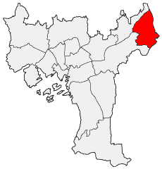
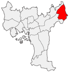
Stovner
- Stovner
-
Wikimedia Foundation.
2010.
Contenu soumis à la licence CC-BY-SA. Source : Article Stovner de Wikipédia en français (auteurs)
Regardez d'autres dictionnaires:
Stovner — Lage von Stovner in Oslo Stovner ist ein nordöstlicher Stadtteil der norwegischen Hauptstadt Oslo. Er hat 29.351 Einwohner (2008) und eine Fläche von 8,2 km². Der Stadtteil grenzt im Norden an die Kommune Nittedal, im Nordosten und Osten an… … Deutsch Wikipedia
Stovner — Infobox Bydel name=Stovner idnumber=030111 city=Oslo capital= governor= governor as of= arearank= area=8.25 areapercent= population as of=2004 populationrank= population=27,885 populationpercent= populationdensity= webpage=www.bydel… … Wikipedia
Stovner (station) — Infobox T bane station name = Stovner caption = locale = Stovner municipality = Oslo line = Grorudbanen distance = 13.7 km elevation = coordinates = coord|59|57|43|N|10|55|23|E|display=title,inline|region:NO 03 scale:50000 type:railwaystation… … Wikipedia
Vestli (station) — Infobox T bane station name = Vestli caption = Detail of station interior locale = Stovner municipality = Oslo line = Grorudbanen distance = 15.1 km elevation = 195.8 m coordinates = coord|59|58|19|N|10|55|42|E|display=title,inline|region:NO 03… … Wikipedia
Revenge (Syndrom album) — Infobox Album | Name = Revenge Type = studio Artist = Syndrom Released = Friday 13, 2008 Recorded = 2007/2008 at Stovner Rockefabrikk, Oslo, Norway Genre = Melodic death metal, Melodic black metal Label = Self financed Last album = This album =… … Wikipedia
East End and West End of Oslo — A map of central Oslo. Uelands gate, the traditional boundary line between the East End and the West End, is marked in black. The East End and West End (Norwegian: Østkanten og Vestkanten) are used as names for the two parts of Oslo, Norway,… … Wikipedia
Rommen (station) — Infobox T bane station name = Rommen caption = locale = Romsås municipality = Oslo line = Grorudbanen distance = 13.0 km elevation = coordinates = coord|59|57|41|N|10|54|28|E|display=title,inline|region:NO 03 scale:50000 type:railwaystation start … Wikipedia
Migraine — Classification et ressources externes La douleur d une migraine peut parfois être intense. CIM 10 … Wikipédia en Français
Streets in Oslo — This is a list of the Streets in Oslo, Norway. Contents 1 Aasta Hansteens vei 2 Abbediengen terrasse 3 Abbediengveien 4 Aasmund Vinjes vei … Wikipedia
Migraine — This article is about the disorder. For other uses, see Migraine (disambiguation). Migraine Classification and external resources The pain of a migraine headache can be debilitating. ICD 10 … Wikipedia

 Portail de l’architecture et de l’urbanisme
 Portail d'Oslo