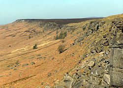
Stanage Edge
Contenu soumis à la licence CC-BY-SA. Source : Article Stanage Edge de Wikipédia en français (auteurs)
Regardez d'autres dictionnaires:
Stanage Edge — Elevation 458 m (1,503 ft) … Wikipedia
Derwent Edge — The Salt Cellar with Ladybower Reservoir in the Background Elevation 538 m (1,765 f … Wikipedia
Rock climbing in the Peak District — Rock climbing is a popular activity in the Peak District; particularly on edges such as Stanage or Froggatt. Generally the climbing style is free climbing (as opposed to aid climbing) and the rock is either gritstone or limestone. Climbing has… … Wikipedia
Millstone Grit — The Salt Cellar, a gritstone tor on Derwent Edge in the Peak District, England Millstone Grit is the name given to any of a number of coarse grained sandstones of Carboniferous age which occur in the Northern England. The name derives from its… … Wikipedia
Ron Fawcett — (* 6. Mai 1955[1]) ist ein englischer Sportkletterer. Er gilt als einer der Väter des modernen Sportkletterns und war Erstbegeher zahlreicher schwerer Kletterrouten vor allem in seiner Heimat. Er war in den 1970er und 1980er Jahren einer der… … Deutsch Wikipedia
Hathersage — infobox UK place country = England latitude= 53.33 longitude= 1.658 official name= Hathersage map type= Derbyshire population = shire district= Derbyshire Dales shire county = Derbyshire region= East Midlands constituency westminster= High Peak… … Wikipedia
Nick Clegg — The Right Honourable Nick Clegg MP Deputy Prime Minister of the United Kingdom … Wikipedia
Crook Hill — The twin summits of Crook Hill above Ladybower Reservoir Elevation 382 m (1,253 … Wikipedia
Mam Tor — This article is about a peak. For the English independent comic book publisher, see Mam Tor Publishing. Mam Tor Mam Tor from the south, March 2005 … Wikipedia
Dovedale — Coordinates: 53°03′35″N 1°46′36″W / 53.0597°N 1.7767°W / 53.0597; 1.7767 … Wikipedia
 Royaume-Uni
 Angleterre
