Sierra Madre (Philippines)
- Sierra Madre (Philippines)
-
16°20′N 122°00′E / 16.333, 122
La Sierra Madre est une chaîne de montagnes située dans le nord-est de l'île de Luçon, aux Philippines.
Elle s'étend sur un axe nord-sud de la province de Cagayan à celle de Quezon le long de la mer des Philippines. Au nord, elle est parallèle à la cordillère Centrale, créant la vallée du Cagayán. Son point culminant est le mont Anacuao, à 1 850 m d'altitude.
Faune
Les forêts de la Sierra Madre abritent une espèce de varan endémique de Luçon, Varanus bitatawa, décrit en avril 2010.

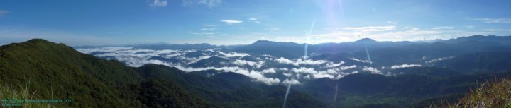
Panorama de la Sierra Madre
Wikimedia Foundation.
2010.
Contenu soumis à la licence CC-BY-SA. Source : Article Sierra Madre (Philippines) de Wikipédia en français (auteurs)
Regardez d'autres dictionnaires:
Sierra Madre (Philippines) — The Sierra Madre is a mountain range in the Philippines. It is the longest in the country (about 210 mi) and runs the north eastern coast of Luzon island. It starts in the province of Cagayan in the north and ends in Quezon in the south, just… … Wikipedia
Sierra Madre — (Spanish for the mother of all saws ) may refer to one of several mountain ranges:*In Mexico: **Sierra Madre Occidental, a mountain range in northwestern Mexico and southern Arizona **Sierra Madre Oriental, a mountain range in northeastern Mexico … Wikipedia
Sierra Madre — Cette page d’homonymie répertorie les différents sujets et articles partageant un même nom. Sierra Madre est le nom de plusieurs chaînes de montagnes : Mexique : Sierra Madre orientale Sierra Madre occidentale Sierra Madre del Sur… … Wikipédia en Français
Sierra mountains — A sierra is a word from the Spanish language meaning a mountain range (serra in Portuguese and Latin). It is used for various mountains and mountain ranges in Spanish and Portuguese speaking countries.Sierra mountains or Sierra Mountain may refer … Wikipedia
PHILIPPINES — Les Philippines sont situées dans l’océan Pacifique à une latitude de 210 25 et 40 23 nord. Le pays a une superficie de 300 000 kilomètres carrés. Ses 7 100 îles ou îlots constituent un archipel montagneux et volcanique au climat chaud et humide… … Encyclopédie Universelle
Philippines — /fil euh peenz , fil euh peenz /, n. (used with a pl. v.) an archipelago of 7083 islands in the Pacific, SE of China: formerly (1898 1946) under the guardianship of the U.S.; now an independent republic. 76,103,564; 114,830 sq. mi. (297,410 sq.… … Universalium
Policies, activities and history of the Philippines in Spratly Islands — This article discusses the policies, activities and history of the Republic of the Philippines in the Spratly Islands. It also discusses the general feelings of Filipino people about the issue, causing this article to discuss some anti Chinese… … Wikipedia
Geography of the Philippines — Country geography name = the Philippines continent = Asia region = Southeast Asia coordinates = 13°00 N 122°00 E area ranking = 72nd km area = 300000 percent land = 99.38 km coastline = 36289 borders = None northernmost point = Y Ami island… … Wikipedia
Valenzuela, Philippines — Valenzuela Lungsod ng Valenzuela City … Wikipedia
Campus of University of the Philippines Los Baños — Alumni Plaza was the college entrance until 1967. Sculpted by … Wikipedia
 Philippines
 Catégories :