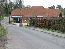
Petham
Contenu soumis à la licence CC-BY-SA. Source : Article Petham de Wikipédia en français (auteurs)
Regardez d'autres dictionnaires:
Petham — infobox UK place country = England official name= Petham latitude= 51.2229 longitude= 1.0471 static static image caption=Petham village hall population = 673 [ [http://www.neighbourhood.statistics.gov.uk/dissemination/LeadTableView.do?a=3… … Wikipedia
City of Canterbury — For the settlement within the City of Canterbury, see Canterbury. For the local government area in Australia, see City of Canterbury (New South Wales). City of Canterbury Non metropolitan district, Borough, City … Wikipedia
List of schools in Kent — List of primary schools, middle schools, secondary schools, special schools, further education colleges and universities in the ceremonial county of Kent, England. [cite web | title = UK Schools Colleges Database | publisher = Schools Web… … Wikipedia
May 10 — << May 2011 >> Su Mo Tu We Th Fr Sa 1 2 3 4 5 … Wikipedia
Canterbury — For the larger local government district, see City of Canterbury. For other uses, see Canterbury (disambiguation). Coordinates: 51°16′30″N 1°05′13″E / 51.275°N 1.0 … Wikipedia
Tungabhadra River — Infobox River | river name = Tungabhadra River |100px caption = Tungabhadra River at Hampi origin = Koodali, Shimoga district, Karnataka mouth = basin countries = India length = elevation = discharge = watershed =The Tungabhadra River is a sacred … Wikipedia
Chartham — Coordinates: 51°15′18″N 1°01′14″E / 51.255°N 1.0205°E / 51.255; 1.0205 … Wikipedia
Chartham Hatch — Coordinates: 51°15′18″N 1°01′14″E / 51.255°N 1.0205°E / 51.255; 1.0205 … Wikipedia
List of hundreds of England and Wales — This is a list of hundreds of England and Wales. Most English counties were divided into hundreds from the late Saxon period and they were effectively abolished under the Local Government Act of 1894.Fact|date=February 2007 In some areas,… … Wikipedia
Joseph McManners — Infobox musical artist Name = Joseph McManners Img capt = Img size = 180 Landscape = yes Background = solo singer Birth name = Joseph McManners Alias = Born = birth date and age|1992|12|3 Died = Origin = Canterbury, UK Instrument = violin, piano … Wikipedia

