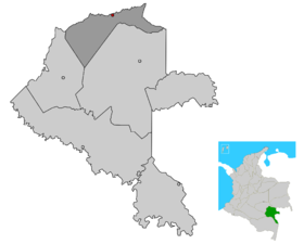
Papunahua
- Papunahua
-
Wikimedia Foundation.
2010.
Contenu soumis à la licence CC-BY-SA. Source : Article Papunahua de Wikipédia en français (auteurs)
Regardez d'autres dictionnaires:
Papunahua — is a town and Department Corregimiento located in the Vaupés Department, Republic of Colombia … Wikipedia
Pacoa — 0° 03′ 00″ N 71° 13′ 00″ W / 0.05, 71.216667 … Wikipédia en Français
Yavaraté — 0° 36′ N 69° 12′ W / 0.6, 69.2 … Wikipédia en Français
Vaupés Department — Department of Vaupés Departamento del Vaupés Department … Wikipedia
Mitú — For the genus of curassows, see Mitu (bird). Mitú City and municipality Location of the town and municipali … Wikipedia
Municipalities of Colombia — The Municipalities of Colombia are decentralized subdivisions of the Republic of Colombia. Municipalities make up most of the departments of Colombia with 1,119 municipalities (municipios). Each one of them is led by a Mayor (Alcalde) elected by… … Wikipedia
Mitú — 1° 12′ 00″ N 70° 10′ 00″ W / 1.2, 70.166667 … Wikipédia en Français
Municipalités de Colombie — Municipalités de Colombie. Les municipalités de Colombie sont des subdivisions décentralisées de troisième niveau (après le niveau national et le niveau départemental) de la République de Colombie. Les 1 119 municipalités (municipios)… … Wikipédia en Français
Vaupés — 1° 12′ 00″ N 70° 10′ 00″ W / 1.2, 70.16666667 … Wikipédia en Français
Acaricuara — Localisation de la municipalité de Mitú dont dépend Acaricuara. Acaricuara est, avec Villa Fátima, l un des deux corregimientos municipaux dépendant de la municipalité de Mitú dans le département de Vaupés en Colombie. Lien externe … Wikipédia en Français
 Colombie
 Vaupés


