Loch Watten
- Loch Watten
-
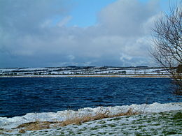
Le loch Watten est un loch de la région de Caithness, en Écosse, dans le bassin de la rivière Wick. Le nom est une tautologie, composé du mot "loch" (d'origine gaélique) et "Vatn", mot norrois signifiant la même chose, comme dans des noms tels que "Þingvallavatn» et "Mývatn" en Islande, et "Røssvatnet" et "Møsvatn" en Norvège.
Il est célèbre pour la pêche à la mouche bon pour la truite brune. Le village de Watten est situé au sud du loch.
Liens internes
Wikimedia Foundation.
2010.
Contenu soumis à la licence CC-BY-SA. Source : Article Loch Watten de Wikipédia en français (auteurs)
Regardez d'autres dictionnaires:
Loch Watten — Infobox lake lake name = Loch Watten image lake = caption lake = image bathymetry = caption bathymetry = location = Caithness, Scotland coords = coord|58|29|25|N|3|19|46|W|region:GB type:waterbody|display=inline,title type = freshwater loch… … Wikipedia
Watten, Highland — Watten (gbmapping|ND242544) is a small village in Caithness, in the Highland area of Scotland, on the main road (A882 A9) between the county town of Wick and the burgh of Thurso, about twelve kilometres (eight miles) west of Wick and close to… … Wikipedia
Watten — WATTEN, a parish, in the county of Caithness, 10 miles (W. N. W.) from Wick; containing 1266 inhabitants. This place originally formed part of the parish of Bower, from which it was separated about the year 1638; it is situated nearly in the… … A Topographical dictionary of Scotland
Loch Burn, Watten — Loch Burn, flows out of the eastern end of Loch Watten in Caithness, in the Highland area of Scotland, at a height of around 20 metres and about one kilometre north/northeast of the village of Watten. Less than a kilometre east of its source at… … Wikipedia
Watten railway station — Infobox UK disused station name = Watten other name= caption = line = Sutherland and Caithness Railway manager = Highland Railway locale = Loch Watten borough = Highland years = 28 July 1874 events = Open years1 = 13 June 1960 events1 = Closed… … Wikipedia
Loch class frigate — The Loch class was a class of anti submarine (A/S) frigate built for the Royal Navy and her allies during World War II. They were an innovative design based on the experience of 3 years of fighting in the Battle of the Atlantic and attendant… … Wikipedia
Loch [2] — Loch, Nebenfahrwasser oder toter Arm eines versandeten Fahrwassers zwischen Bänken oder Watten … Meyers Großes Konversations-Lexikon
Liste schottischer Lochs — Loch ist das schottisch gälische Wort für einen See oder eine Meeresbucht, einen Fjord (englisch Firth). Das Wort, lɔx, «loch» mit kehligem «ch» ausgesprochen, ist verwandt mit dem altirischen Lough, rekonstruierte indogermanische Wurzel… … Deutsch Wikipedia
Wick, Highland — Coordinates: 58°27′14″N 3°05′20″W / 58.454°N 3.089°W / 58.454; 3.089 … Wikipedia
Wick River — Wick River, known also as River Wick, has its source near Achigale Mill at the northern end of Bardarclay Moss (gbmapping|ND241536) in the Flow Country of Caithness in Highland, Scotland. The river estuary (gbmappingsmall|ND359510), is in the… … Wikipedia
 Royaume-Uni
 Écosse)
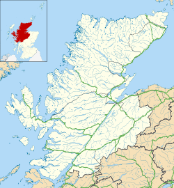


 Portail du monde maritime
 Portail de l’Écosse

