Loch Tulla
- Loch Tulla
-
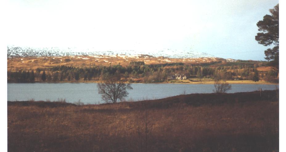
Le loch Tulla (Gaélique écossais: Loch Toilbhe, (lˠ̪ɔxˈt̪ʰɔlɔvə) est un petit loch près de Bridge of Orchy et de Glen Coe en Écosse et des hautes terres centrales. Il héberge des saumons dont certains sont élevés localement.
Liens internes
Wikimedia Foundation.
2010.
Contenu soumis à la licence CC-BY-SA. Source : Article Loch Tulla de Wikipédia en français (auteurs)
Regardez d'autres dictionnaires:
Loch Tulla — von Nordwesten Geographische Lage Argyll and Bute, Schottland … Deutsch Wikipedia
Loch Tulla — Infobox lake lake name = Loch Tulla image lake =Loch Tulla nthview.jpg caption lake = image bathymetry = caption bathymetry = location = Argyll and Bute, Scotland coords = coord|56.54608|N|4.77821|W|region:GB type:watebody source:enwiki… … Wikipedia
Liste schottischer Lochs — Loch ist das schottisch gälische Wort für einen See oder eine Meeresbucht, einen Fjord (englisch Firth). Das Wort, lɔx, «loch» mit kehligem «ch» ausgesprochen, ist verwandt mit dem altirischen Lough, rekonstruierte indogermanische Wurzel… … Deutsch Wikipedia
Denys Rayner — in 1943 Denys Arthur Rayner DSC Bar, VRD, RNVR (9 February 1908 4 January 1967) fought throughout the Battle of the Atlantic. After intensive war service at sea, Rayner became a writer, a farmer, and a successful designer and builder of small… … Wikipedia
Beinn Achaladair — Infobox Mountain Name = Beinn Achaladair Photo = Beinn Achaladair.jpg Caption = Beinn Achaladair seen from the north west near Loch Tulla. Elevation = 1038 m (3405 ft) Location = Argyll Perthshire SCO Range = Bridge of Orchy Hills, Grampians… … Wikipedia
Stob Ghabhar — seen from the south east across Loch Tulla. Elevation … Wikipedia
River Orchy — Orchy Der River Orchy bei der Ortschaft Bridge of OrchyVorlage:Infobox Fluss/KARTE fehlt … Deutsch Wikipedia
Liste des lochs d'Écosse — Ce qui suit est une liste des lochs d Écosse. Cette liste est loin d être exhaustive: seuls les plus connus sont répertoriés. Il a été estimé qu il y a au moins 31 460 lacs d eau douce en Écosse, et plus de 7 500 dans les Hébrides extérieures… … Wikipédia en Français
List of lochs in Scotland — The following is a list of lochs in Scotland. Loch is a Scottish Gaelic word for a lake or fiord, cognate with the Irish Gaelic lough , which has been borrowed by Scots and Scottish English to apply to such bodies of water, especially those… … Wikipedia
Glen Coe — Glencoe ( Gleann Comhann in Gaelic) is a glen in the Highlands of Scotland. It lies in the southern part of the Lochaber committee area of Highland Council, and was formerly part of the county of Argyll. It is often considered one of the most… … Wikipedia

 Royaume-Uni
 Écosse)


 Portail du monde maritime
 Portail de l’Écosse