Garvellachs

Garvellachs
Garvellachs
Garbh Eileaich (gd)
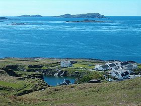
Les Garvellachs (dernier plan) vues depuis Cullipool (premier plan).
Géographie
Pays Drapeau : Royaume-Uni Royaume-Uni
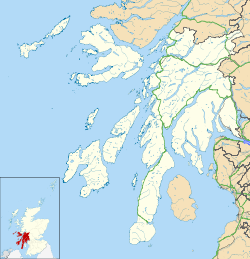
Archipel Hébrides intérieures
Localisation Firth of Lorn (océan Atlantique)
Coordonnées 56° 14′ 00″ N 5° 47′ 00″ W / 56.233333, -5.78333356° 14′ 00″ N 5° 47′ 00″ W / 56.233333, -5.783333
Nombre d'îles 6 et plusieurs rochers
Île(s) principale(s) Garbh Eileach, Dùn Channuill, Eileach an Naoimh, A'Chùli
Point culminant non nommé (env 100 m sur Garbh Eileach)
Géologie Îles continentales
Administration
Drapeau : Royaume-Uni Royaume-Uni
Nation constitutive Écosse
Council area Argyll and Bute
Démographie
Population Aucun habitant
Autres informations
Découverte Préhistoire
Fuseau horaire UTC+0

Géolocalisation sur la carte : Argyll and Bute

(Voir situation sur carte : Argyll and Bute)
Garvellachs
Garvellachs

Géolocalisation sur la carte : Royaume-Uni

(Voir situation sur carte : Royaume-Uni)
Garvellachs
Garvellachs
Archipels du Royaume-Uni

Les Garvellachs, en gaélique écossais Garbh Eileaich, littéralement « Îles de la Mer », en anglais Isles of the Sea, sont un petit archipel inhabité du Royaume-Uni situé en Écosse et baigné par le Firth of Lorn.


Wikimedia Foundation. 2010.

Contenu soumis à la licence CC-BY-SA. Source : Article Garvellachs de Wikipédia en français (auteurs)

Игры ⚽ Поможем написать курсовую

Regardez d'autres dictionnaires:

  • Garvellachs — Islas Garvellachs (Garbh Eileaich) Vista de las Garvellachs Localización geográfica / administrativa …   Wikipedia Español

  • Garvellachs — The Garvellachs (Scottish Gaelic: Garbh Eileaich) or Isles of the Sea form a small archipelago in the Inner Hebrides of Scotland. Part of the Argyll and Bute council area, they lie west of Lunga and northwest of Scarba and have been uninhabited… …   Wikipedia

  • Craobh Haven — is a small purpose built village and sailing port on the west coast of Argyll and Bute, Scotland. It is situated on the Craignish peninsula, one mile to the west of the A816, and approximately 22 miles (35 km) south of Oban. Craobh Haven is… …   Wikipedia

  • Hinba — ( gd. isles of the sea ) is an island in Scotland of unknown location that was the site of a small monastery associated with the Columban church on Iona. Although a number of details are known about the monastery and its early abbots, and various …   Wikipedia

  • Список островов Шотландии — Карта Внешних и Внутренних Гебрид Этот список содержит перечисление морских и пресноводных островов Шотландии (континентальная часть которой является частью острова Великобритания). Помимо того, в список включены связанные с рас …   Википедия

  • Scarba — Location …   Wikipedia

  • Garbh Eileach — Infobox Scottish island | latitude=56.24 longitude= 5.77 GridReference=NM665115 celtic name=Garbh Eileach norse name= meaning of name=rough rocky mound area=142 ha area rank= 128= highest elevation= 110 m Population=0 population rank= main… …   Wikipedia

  • Lunga, Firth of Lorn — Infobox Scottish island latitude=56.22 longitude= 5.70 GridReference=NM706086 celtic name=Lunga norse name=Langr oy meaning of name= Old Norse for isle of the longships area=254 ha (628 acres) area rank=96 highest elevation= Bidean na h Iolaire… …   Wikipedia

  • Dùn Channuill — Location …   Wikipedia

  • Eileach an Naoimh — Vorlage:Infobox Insel/Wartung/Fläche fehltVorlage:Infobox Insel/Wartung/Höhe fehlt Eileach an Naoimh Mönchszelle und …   Deutsch Wikipedia

Share the article and excerpts

Direct link
Do a right-click on the link above
and select “Copy Link”