Fraserdale
Contenu soumis à la licence CC-BY-SA. Source : Article Fraserdale de Wikipédia en français (auteurs)
Regardez d'autres dictionnaires:
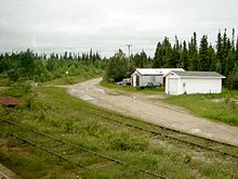
Fraserdale, Ontario — Fraserdale is a small community in Northern Ontario. It is located 131km north of Timmins.The community /train stop was named for Alan Fraser, railway engineer. The neighbouring community Abitibi Canyon (4.5 kilometers east), was the most… … Wikipedia
Highway 807 (Ontario) — Infobox road highway name = Highway 807 marker length km = 73 length notes = direction a = North direction b = South direction = North/South starting terminus = Fraserdale ending terminus = jct|state=ON|Hwy|11 in Smooth Rock Falls cities = Smooth … Wikipedia
Highway 634 (Ontario) — Infobox road highway name = Highway 634 marker length km = 80.3 length notes = direction a = North direction b = South direction = North/South starting terminus = Abitibi Canyon Hydroelectric dam at Otter Rapids, Ontario ending terminus = Highway … Wikipedia
Ontario Highway 634 — Highway 634 Route information Length: 80.3 km (49.9 mi) History: Opened July 21, 1966 … Wikipedia
Abitibi Canyon — 49°52′40″N 81°34′15″O / 49.87778, 81.57083 Abitibi Canyon est une communauté canadienne … Wikipédia en Français
List of communities in Ontario — Communities in the province of Ontario, Canada Note: this is an incomplete list of communities, not necessarily organized municipalities. For organized municipalities see list of municipalities in Ontario and for census subdivisions see list of… … Wikipedia
Ontario Northland Railway — The ONR owned tracks in blue with trackage rights in red … Wikipedia
Cochrane, Unorganized, North Part, Ontario — Cochrane, Unorganized, North Part is an unorganized area in the District of Cochrane in northeastern Ontario, Canada. It comprises all parts of the district north of Timmins and Iroquois Falls which are not part of an incorporated… … Wikipedia
Abitibi River — The Abitibi River is a river in northeastern Ontario, Canada, which flows northwest from Lake Abitibi to join the Moose River which empties into James Bay. This river is convert|540|km long.The river was an important fur trading route for the… … Wikipedia
Nepean, Ontario — Coordinates: 45°20.5′N 75°45.5′W / 45.3417°N 75.7583°W / 45.3417; 75.7583 … Wikipedia
 Fraserdale
