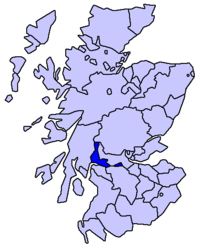
- Dunbartonshire
-
Dumbarton [[Fichier:  |200px|alt=Image illustrative de l'article Dunbartonshire]]
Géographie Superficie 29e - Total 625 km² km² - % eau Capitale administrative Dumbarton ISO 3166-2 Code ONS Démographie Population [[Liste des council areas écossais par population en 2004|]] - Total () Politique Majorité Le Dunbartonshire (Siorrachd Dhùn Bhreatainn en gaélique écossais) ou le comté de Dumbarton, est une région de lieutenance et un ancien comté des Central Lowlands en Écosse. Jusqu'en 1975 il fait partie des comtés d'Écosse avec pour capitale Dumbarton. La régions avait auparavant appartenu au district de Lennox, qui était un duché de la pairie d'Écosse dirigé par le Duc de Lennox.
Dans l'administration moderne, le comté est divisé en 2 des 32 council areas du pays, l'East Dunbartonshire, basé à Kirkintilloch, et le West Dunbartonshire, dont le centre administratif est à Dumbarton.
Sommaire
Nom
Dumbarton est la capitale du comté qui était nommé à l'origine Dumbartonshire. Au XVIIIe siècle le "Comté de Dunbarton" et "Comté de Dumbarton" sont utilisés indistinctement[1].
Frontières
Malgré la refonte des limites de comtés de 1890, le dumbartonshire conserve une importante exclave composée des paroisses de Kirkintilloch et Cumbernauld, entre le Stirlingshire et le Lanarkshire : cette zone faisait partie à l'origine du Stirlingshire, mais a été annexé à Dunbarton sous le règne de David II à la requête de Malcolm Fleming, comte de Wigtown, propriétaire des lieux, et également shérif à Dumbarton[2].
Disparition du comté
On retire le rôle administratif des comtés en 1975 avec le Local Government (Scotland) Act 1973, et le Dumbartonshire est alors intégré au Strathclyde. Le Strathclyde comprend 19 districts, et l'aire originellement comprise dans le comté est répartie dans les distrcits de Dumbarton, de Bearsden and Milngavie, de Clydebank, de Cumbernauld and Kilsyth et de Strathkelvin, ce dernier comprenant également une petite partie de l'ancien Lanarkshire.
Références
- Crown Lands - Forfeited Estates Act, 1784 (1784 c. 57) et Manning of the Navy Act, 1795 (1795 c. 29)
- Cumbernauld, A Topographical Dictionary of Scotland (1846)(British History Online)
Liens externes
- (en)"The Book of Dumbartonshire", J. Scott Keltie in Macmillan's Magazine, Vol. LXII, May to Oct., 1880, pp. 33–42
- (en)A Short History of Dumbartonshire I.M.M. MacPhail
Catégories :- Comté d'Écosse
- Région de lieutenance d'Écosse
Wikimedia Foundation. 2010.
