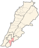
- District de Marjayoun
-
District de Marjayoun
(قضاء مرجعيون) Carte de localisation du district.
Administration Pays  Liban
LibanType District Gouvernorat Nabatieh Chef-lieu Marjayoun Géographie Superficie 265 km2 Population Population 41 000 hab. (est. 2008) Densité 154,7 hab./km2 Le caza de Marjayoun est un district du Gouvernorat de Nabatieh au Sud du Liban. Le Chef lieu du district, est la ville du même nom, Marjayoun. Une autre ville importante du Caza est Khiam.
Marjayoun est une ville colline qui surplombe en faisant face au Mont Hermon à l'est, au Château de Beaufort à l'ouest au dessus du Litani.
Répartition confessionnelle des habitants
source: version arabe
Confessions Pourcentage TOTAL CHRÉTIENS 16% Maronites 5 Grecs-orthodoxes 7 Grecs-catholiques 3 Autres chrétiens 1 TOTAL MUSULMANS 84% Sunnites 3 Chiites 80 Druzes 1 Alaouites 0 Photos de Marjeyoun
Album photo de Marjayoun
Baladiyat Marjayoun Gallerie photoUne vue par satellite de Marjayoun
Liens externes

Districts du Liban Akkar | Aley | Baabda | Baalbek | Batroun | Bcharré | Bekaa occidentale | Bint-Jbeil | Chouf | Hasbaya | Hermel | Jbeil | Jezzine | Kesrouan | Koura | Marjayoun | Metn | Minieh-Denieh | Nabatieh | Rachaya | Sidon | Tripoli | Tyr | Zahlé | Zghorta
Nota : Le Gouvernorat de Beyrouth n'est pas divisé en districts.
Catégorie :- District du Liban
Wikimedia Foundation. 2010.
