Barton Highway

Barton Highway
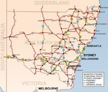
Carte routière de Nouvelle-Galles du Sud. La Barton Highway est la nationale 25

La Barton Highway (Nationale 25) est un tronçon routier orienté grossièrement nord-sud et long de 62 km situé en Nouvelle-Galles du Sud et dans le Territoire de la capitale australienne, en Australie. Elle démarre, au sud, de la Federal Highway dans le quartier de Barton au nord de Canberra pour s'achever au nord sur la Hume Highway, 5km à l'est de Yass et constitue une partie du tronçon routier reliant Melbourne à Canberra. Elle doit son nom à Sir Edmund Barton, le premier premier ministre d'Australie.

La route est de type autoroutier dans le territoire de la capitale australienne et dans ses six derniers km de contournement de Yass, elle est à deux voies sur le reste de son parcours avec des zones de dépassement. Il est prévu qu'elle soit mise à quatre voies à une échéance 2012 à 2016. Bien que la route soit de bonne qualité, elle est considérée en raison de l'importance de son trafic comme la pire des routes de Nouvelle-Galles du Sud.

La vitesse est limitée à 100km/h sur son parcours sauf sur le contournement de Yass où elle est limitée à 110.

Principales intersections et localités sur son trajet

Barton Highway Australian National Route 25.svg Australian Tourist Route 4.jpg
Vers le Nord Distance à
Melbourne
(km)
Distance à
Canberra
(km)
Vers le Sud
Fin de la Barton Highway Australian National Route 25.svg
continue sous le nom de Hume Highway Australian National Route 31.svg
jusqu'à Gundagai / Melbourne / Adélaïde
608 56 Début de la Barton Highway Australian National Route 25.svg
à partir de Hume Highway Australian National Route 31.svg
Goulburn, Sydney
Hume Highway Australian National Route 31.svg échangeur
Yass
Yass Valley Way échangeur
612 52 Yass
Yass Valley Way Grade Separated Intersection
Murrumbateman 626 38 Murrumbateman
Gundaroo, Bungendore
Murrumbateman Road High Speed Intersection
Gundaroo, Bungendore
Murrumbateman Road High Speed Intersection
NOUVELLE-GALLES DU SUD
FRONTIERE
TERRITOIRE DE LA CAPITALE AUSTRALIENNE
Hall
Victoria Street High Speed Intersection
648 16 Hall
Victoria Street High Speed Intersection
Hall
Victoria Street High Speed Intersection
651 13 Hall
Victoria Street High Speed Intersection
continue sous le nom de Australian National Route 25.svg 651.5 12.5 Fraser, Belconnen
Kuringa Drive _Australian Tourist Route 4.jpg High Speed Intersection
Fraser, Belconnen
Kuringa Drive _Australian Tourist Route 4.jpg High Speed Intersection
_en_double_avec_Australian Tourist Route 4.jpg en double avec Australian National Route 25.svg
Gungahlin
Gundaroo Drive
Belconnen
William Slim Drive Give way sign at roundabout (Australia).svg
654 10 Gungahlin
Gundaroo Drive
Belconnen
William Slim Drive Give way sign at roundabout (Australia).svg
Gungahlin
Gunghalin Drive Grade Separated Intersection
657.5 6.5 Gungahlin
Gunghalin Drive Grade Separated Intersection
Belconnen, Woden
Gunghalin Drive Grade Separated Intersection Australian traffic lights ahead sign.png
657.7 6.3 Belconnen, Woden
Gunghalin Drive Grade Separated Intersection Australian traffic lights ahead sign.png
Début de la Barton Highway Australian National Route 25.svg 660 4 Fin de la Barton Highway Australian National Route 25.svg
Australian traffic lights ahead sign.png Traffic Lights (clockwise from highway)
Federal Highway Australian National Route 23.svg vers Watson, Goulburn et Sydney
Northbourne Avenue Australian Route 23.svg Australian Tourist Route 4.jpg vers Canberra centre, Queanbeyan et Cooma Canberra International Airport

Wikimedia Foundation. 2010.

Contenu soumis à la licence CC-BY-SA. Source : Article Barton Highway de Wikipédia en français (auteurs)

Игры ⚽ Поможем написать курсовую

Regardez d'autres dictionnaires:

  • Barton Highway — Von …   Deutsch Wikipedia

  • Barton Highway — Infobox Australian Road road name = Barton Highway route route route photo = caption = length = 56 direction = North South start = finish = est = through = Murrumbateman route = exits = Yass Valley WayThe Barton Highway [… …   Wikipedia

  • Barton Creek, Austin, Texas — Barton Creek is a neighborhood located west of West Lake Hills Texas, west of the Lost Creek neighborhood, and east of the town of Bee Cave Texas. The Barton Creek neighborhood is just south of Bee Caves Road (Ranch to Market Road 2244) and west… …   Wikipedia

  • Barton County, Kansas — Infobox U.S. County county=Barton County state=Kansas founded=February 26, 1867 seat wl=Great Bend area total km2=2332|area total sq mi=900 area land km2=2315|area land sq mi=894 area water km2=17|area water sq mi=6 area percentage=0.72% census… …   Wikipedia

  • Barton, Vermont — For the village, see Barton (village), Vermont. Infobox Settlement official name = Barton, Vermont other name = native name = nickname = settlement type = Town motto = imagesize = image caption = flag size = image seal size = image shield =… …   Wikipedia

  • Barton, New York — Infobox Settlement official name = Barton, New York settlement type = Town nickname = motto = imagesize = image caption = image |pushpin pushpin label position = pushpin map caption =Location within the state of New York pushpin mapsize = mapsize …   Wikipedia

  • Barton's Club 93 — Infobox hotel hotel name = Barton s Club 93 image width = caption = location = Highway 93 Jackpot, Nevada coordinates = opening date = 1967 stars = diamonds = closing date = developer = architect = operator = Club 93 Inc. owner = Club 93 Inc.… …   Wikipedia

  • Barton Hills, Austin, Texas — Owing its name to William Uncle Billy Barton, this Austin, Texas neighborhood was originally set up in the 19th century as a pioneer homestead near the natural springs of the Colorado river. Bordered by South Lamar to the east, Loop 1 to the west …   Wikipedia

  • Hume Highway — Hume Freeway Proposed …   Wikipedia

  • Monaro Highway — Monaro Highway …   Wikipedia

Share the article and excerpts

Direct link
Do a right-click on the link above
and select “Copy Link”