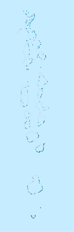
Atoll Hadhdhunmathi

Atoll Hadhdhunmathi
Atoll Hadhdhunmathi
ހައްދުންމަތި (dv)
Carte de l'atoll Hadhdhunmathi.
Géographie
Pays Drapeau des Maldives Maldives
Archipel Maldives
Localisation Océan Indien
Coordonnées 1° 56′ 00″ N 73° 25′ 00″ E / 1.933333, 73.4166671° 56′ 00″ N 73° 25′ 00″ E / 1.933333, 73.416667
Superficie 23,1 km2
Nombre d'îles 82
Géologie Atoll
Administration
Statut Subdivision administrative

Drapeau des Maldives Maldives
Province Mathi-Dhekunu
Démographie
Population 14 313 hab.
Densité 619,61 hab./km2
Plus grande ville Fonadhoo
Autres informations
Découverte Préhistoire
Fuseau horaire UTC+5

Géolocalisation sur la carte : Maldives

(Voir situation sur carte : Maldives)
Atoll Hadhdhunmathi
Atoll Hadhdhunmathi
Atolls des Maldives

L'atoll Hadhdhunmathi, en divehi ހައްދުންމަތި, est un atoll des Maldives. Ses 14 313 habitants se répartissent sur 12 des 82 îles qui le composent. Les terres émergées représentent 23,1 km2 sur les 884,63 km2 de superficie totale de l'atoll, lagon inclus[1].

Administration

Laamu
Carte de localisation de Atoll Hadhdhunmathi.
Province Mathi-Dhekunu
Lettre divehi ލ
Lettre latine O
Coordonnées 1° 56′ 00″ Nord
       73° 25′ 00″ Est
/ 1.933333, 73.416667
1° 56′ 00″ N 73° 25′ 00″ E / 1.933333, 73.416667
Atoll(s) et île(s) Atoll Hadhdhunmathi
Nombre d'îles 82 dont 12 habitées
Superficie 23,1 km2
Population 14 313 hab.
Densité 619,61 hab./km2
Capitale Fonadhoo

L'atoll Hadhdhunmathi constitue une subdivision des Maldives sous le nom de Laamu. Sa capitale est Fonadhoo.

Référence


Wikimedia Foundation. 2010.

Contenu soumis à la licence CC-BY-SA. Source : Article Atoll Hadhdhunmathi de Wikipédia en français (auteurs)

Игры ⚽ Нужно сделать НИР?

Regardez d'autres dictionnaires:

  • Atoll Nilandhe Nord — ނިލަންދެއަތޮޅު އުތުރުބުރި (dv) Carte de l atoll Nilandhe Nord. Géographie Pays …   Wikipédia en Français

  • Atoll Faadhippolhu — ފާދިއްޕޮޅު (dv) Carte de l atoll Faadhippolhu. Géographie Pays …   Wikipédia en Français

  • Atoll Kolhumadulu — ކޮޅުމަޑުލު (dv) Carte de l atoll Kolhumadulu. Géographie Pays …   Wikipédia en Français

  • Atoll Mulaku — މުލަކަތޮޅު (dv) Carte de l atoll Mulaku. Géographie Pays …   Wikipédia en Français

  • Atoll Nilandhe Sud — ނިލަންދެއަތޮޅު ދެކުނުބުރި (dv) Carte de l atoll Nilandhe Sud. Géographie Pays …   Wikipédia en Français

  • Atoll Ari — Image satellite de l atoll Ari avec l atoll Rasdu en haut à droite. Géographie Pays …   Wikipédia en Français

  • Atoll Maalhosmadulu Nord — Carte de l atoll Maalhosmadulu Nord avec l île isolée de Alifushi en haut. Géographie Pays …   Wikipédia en Français

  • Atoll Alifushi — އަލިފުށި (dv) Géographie Pays  Maldives …   Wikipédia en Français

  • Atoll Felidhu — Carte de l atoll Felidhu avec le récif Vattaru à gauche. Géographie Pays …   Wikipédia en Français

  • Atoll Maalhosmadulu Sud — Carte de l atoll Maalhosmadulu Sud. Géographie Pays …   Wikipédia en Français

Share the article and excerpts

Direct link
Do a right-click on the link above
and select “Copy Link”