Ahırlı
- Ahırlı
-
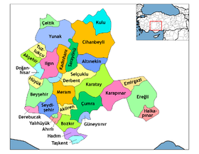
Ahırlı est une ville et un district de la province de Konya dans la région de l'Anatolie centrale en Turquie.
Géographie
Cette section est vide, insuffisamment détaillée ou incomplète.
Votre aide est la bienvenue !
Histoire
Cette section est vide, insuffisamment détaillée ou incomplète.
Votre aide est la bienvenue !
Catégorie :
- Localité de la région de l'Anatolie centrale
Wikimedia Foundation.
2010.
Contenu soumis à la licence CC-BY-SA. Source : Article Ahırlı de Wikipédia en français (auteurs)
Regardez d'autres dictionnaires:
Ahırlı — Infobox Settlement settlement type = District subdivision type = Country subdivision name = TUR timezone= EET utc offset=+2 map caption =Location of PAGENAME within Turkey. timezone DST=EEST utc offset DST=+3 official name = Ahırlı image caption … Wikipedia
Ahirli — Original name in latin Ahrl Name in other language Ahirli, Ahrl State code TR Continent/City Europe/Istanbul longitude 37.23874 latitude 32.11881 altitude 1221 Population 0 Date 2012 05 06 … Cities with a population over 1000 database
Ahırlı — is., öz. Konya iline bağlı ilçelerden biri … Çağatay Osmanlı Sözlük
aranlıg — ahırlı, ahırı olan I, 148 … Divan-i Luqat-i it-Türk Dizini
Konya — For other uses, see Konya (disambiguation). Konya Konya Collage … Wikipedia
Konya Province — Infobox Province TR region = Central Anatolia name = Konya licence = 42 total population = 2,412,104 area code = 332 area = 38,257|Konya is a province of Turkey located in central Anatolia. The provincial capital is the city of Konya. It is the… … Wikipedia
Altınekin — Infobox Settlement settlement type = District subdivision type = Country subdivision name = TUR timezone= EET utc offset=+2 map caption =Location of PAGENAME within Turkey. timezone DST=EEST utc offset DST=+3 official name = Altınekin image… … Wikipedia
Çumra — District Location of Çumra within Turkey. Coordinates … Wikipedia
Derebucak — District Location of Derebucak within Turkey. Coordinates … Wikipedia
Doğanhisar — District Location of Doğanhisar within Turkey. Coordinates … Wikipedia
 Turquie
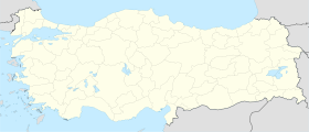
 Ahırlı
