Wallblake
- Wallblake
-
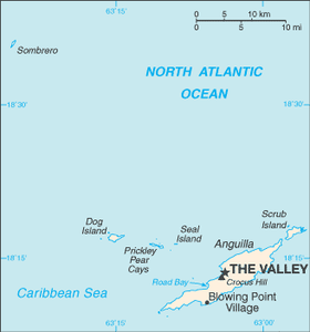
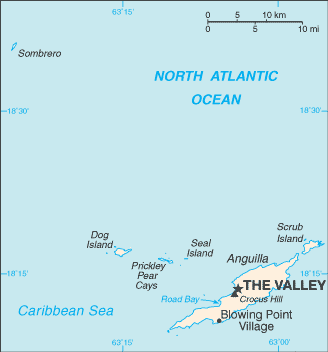
The Valley (Anguilla)
The Valley est la capitale du territoire britannique d'outre-mer d'Anguilla. La ville comptait 1 169 habitants en 2001[1].
The Valley posséde un aéroport (Wallblake, code AITA : AXA).
Curiosité
Le groupe du Duran Duran pour leur 12° album Red Carpet Massacre ont intitulé la première trace du disque vraiment The Valley.
Notes et références
Wikimedia Foundation.
2010.
Contenu soumis à la licence CC-BY-SA. Source : Article Wallblake de Wikipédia en français (auteurs)
Regardez d'autres dictionnaires:
Aéroport de Wallblake — Anguilla Wallblake Airport Code AITA Code OACI AXA … Wikipédia en Français
Anguilla Wallblake Airport — Infobox Airport name = Anguilla Wallblake Airport nativename = IATA = AXA ICAO = TQPF type = Public owner = operator = Government city served = location = The Valley, Anguilla metric elev = elevation f = 127 elevation m = 39 coordinates =… … Wikipedia
Clayton J. Lloyd International Airport — Wallblake Airport IATA: AXA – ICAO: TQPF Summary … Wikipedia
The Valley, Anguilla — Infobox Settlement name = official name = The Valley other name = native name = nickname = settlement type =Town total type = motto = imagesize = image caption = flag size = image seal size = image shield = shield size = image blank emblem =… … Wikipedia
Trans Anguilla Air — Infobox Airline airline = Trans Anguilla Air logo = logo size = 250 fleet size = destinations = 21 IATA = ICAO = callsign = parent = Trans Anguilla Air 2000 Limited company slogan = founded = headquarters = key people = hubs = Anguilla Wallblake… … Wikipedia
The Valley (Anguilla) — 18.220833333333 63.051666666667 Koordinaten: 18° 13′ N, 63° 3′ W … Deutsch Wikipedia
Algona Municipal Airport — Infobox Airport name = Algona Municipal Airport IATA = AXG ICAO = KAXA FAA = AXA type = Public owner = City of Algona operator = city served = Algona, Iowa location = elevation f = 1,219 elevation m = 372 coordinates =… … Wikipedia
Anguilla — This article is about the Caribbean British overseas territory. For other uses, see Anguilla (disambiguation). Anguilla … Wikipedia
Transport in Anguilla — An overseas territory of the United Kingdom, the Caribbean island of Anguilla measures only 16 miles long by 3 miles wide, so transport is simpler than in many countries. There is no public transport, such as bus or rail systems, since there isn… … Wikipedia
Vieques Air Link — (VAL) is a small Puerto Rican airline company that links Vieques with Culebra and mainland Puerto Rico. Code Data *IATA Code: VI *ICAO Code: VES *Callsign: Vieques History Operations began on 1965, with owner Osvaldo Gonzalez piloting a plane… … Wikipedia
 Pour les articles homonymes, voir The Valley.
 Royaume-Uni
 Anguilla