Uitweg
Contenu soumis à la licence CC-BY-SA. Source : Article Uitweg de Wikipédia en français (auteurs)
Regardez d'autres dictionnaires:
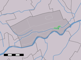
Uitweg — Dutch town locator maps mun town caption = Uitweg in the municipality of Lopik.Uitweg (coord|51|59|N|5|1|E|type:city(121)) is a town in the Dutch province of Utrecht. It is a part of the municipality of Lopik, and lies about 5 km southwest of… … Wikipedia
Lopik — Héraldique … Wikipédia en Français
Lopik — Infobox Settlement official name = Lopik mapsize = 280px subdivision type = Country subdivision name = Netherlands subdivision type1 = Province subdivision name1 = Utrecht leader name = M.A.A. Schakel leader party = CDA area footnotes = (2006)… … Wikipedia
Dutch Water Line — Old Dutch Waterline New Dutch Waterline Netherlands One of the inundation sluices near Utrecht Type … Wikipedia
List of political catch phrases — The following is a list of political catch phrases, that is, distinctive statements uttered by political figures that have gone on to become well known.They are distinct from political slogans in that they are often not deliberately created… … Wikipedia
Lopik — Gemeinde Lopik Flagge Wappen Provinz Utrecht Sitz der Gemeinde Lopik … Deutsch Wikipedia
Benschop — 52°0′26″N 4°58′46″E / 52.00722, 4.97944 … Wikipédia en Français
Cabauw — 51°57′52″N 4°53′54″E / 51.96444, 4.89833 … Wikipédia en Français
Enge IJssel — Caractéristiques Longueur 4,25 km Bassin ? Bassin collecteur Rhin … Wikipédia en Français
Jaarsveld — 51°58′0″N 4°59′0″E / 51.96667, 4.98333 … Wikipédia en Français
 Pays-Bas