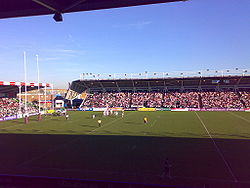
Twickenham Stoop Stadium
- Twickenham Stoop Stadium
-
The Stoop
51°27′1″N 0°20′39″O / 51.45028, -0.34417
The Stoop est une enceinte sportive anglaise dédiée au rugby à XV et rugby à XIII. Localisée à Londres, c'est une arène de 12 700 places utilisée par les Harlequins et les Harlequins Rugby League. En juillet 2005, le nom du stade officiellement transformé de Stoop Memorial Ground en Twickenham Stoop Stadium, mais d'usage courant, c'est The Stoop.
Voir aussi
 Portail du rugby à XV
 Portail du rugby à XIII
 Portail de Londres
Catégories : Stade anglais de rugby à XV | Équipement sportif à Londres
Wikimedia Foundation.
2010.
Contenu soumis à la licence CC-BY-SA. Source : Article Twickenham Stoop Stadium de Wikipédia en français (auteurs)
Regardez d'autres dictionnaires:
The Twickenham Stoop — The Stoop 51°27′1″N 0°20′39″O / 51.45028, 0.34417 … Wikipédia en Français
The Stoop — Infobox Stadium stadium name = The Stoop nickname = fullname = Twickenham Stoop Stadium built = 1963 opened = 1963 seating capacity = 12,700 tenants = Harlequins and Harlequins Rugby League dimensions = Refimprove|date=September 2007The Stoop in… … Wikipedia
The Stoop — Généralités Nom complet Twickenham Stoop Stadium Adresse Langhorn Drive, Twickenham Middlesex, TW2 7SX Angleter … Wikipédia en Français
The Stoop — 2008 The Stoop ist ein Stadion im südwestlichen Londoner Stadtteil Twickenham. Es bietet Platz für 14.816 Zuschauer und ist das Heimstadion zweier Rugbyvereine, des Harlequin F.C. (Rugby Union) bzw. von Harlequins Rugby League (Rugby League).… … Deutsch Wikipedia
Twickenham — infobox UK place country = England map type = Greater London region= London population= official name= Twickenham latitude= 51.4486 longitude= 0.3369 os grid reference= TQ155735 london borough= Richmond post town= TWICKENHAM postcode district=… … Wikipedia
Twickenham — London Borough of Richmond upon Thames Lage in Greater London Status London Borough Region … Deutsch Wikipedia
Millennium Stadium — Stadiwm y Mileniwm The West Stand of the Millennium Stadium … Wikipedia
Murrayfield Stadium — Location … Wikipedia
Galpharm Stadium — Full name Galpharm Stadium Former names Alfred McAlpine Stadium Location Huddersfield, Engl … Wikipedia
Chapel House, Twickenham — 15 Montpelier Row, Twickenham in August 2010. Chapel House, now No. 15, Montpelier Row, Twickenham, is a house in Greater London, England. The house has also been called Tennyson House and Holyrood House.[1] It was occupied at one time by Alfred … Wikipedia


