Terihi
- Terihi
-
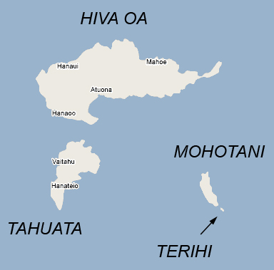
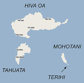
Terihi est une petite île située dans les Îles Marquises en Polynésie française. Elle est située à 800 m au sud-ouest de Moho Tani auquel elle est administrativement rattachée.
Géographie
Terihi est une toute petite île rocheuse de 0,150 km2 située au large de Moho Tani. Inhabitée, elle est partie intégrante de la réserve naturelle de Motane.
Histoire
Cette section est vide, insuffisamment détaillée ou incomplète.
Votre aide est la bienvenue !
Wikimedia Foundation.
2010.
Contenu soumis à la licence CC-BY-SA. Source : Article Terihi de Wikipédia en français (auteurs)
Regardez d'autres dictionnaires:
Terihi — is a small, uninhabited, rocky island in the Marquesas Islands, approximately 1 km (.5 mi.) south southeast from Moho Tani.In 1992, the island became officially protected by its inclusion in the Motane Nature Reserve.ee also*French Polynesia … Wikipedia
Moho Tani — vue depuis HivaOa. Géographie Pays … Wikipédia en Français
Molopu — Moho Tani Moho Tani Moho Tani vue depuis HivaOa. Géographie Pays … Wikipédia en Français
Motane — Moho Tani Moho Tani Moho Tani vue depuis HivaOa. Géographie Pays … Wikipédia en Français
Marquesas Islands — Marquesas redirects here. For the uninhabited island group in the U.S. State of Florida, see Marquesas Keys. Marquesan redirects here. For the language, see Marquesan language. Coordinates: 9°27′16″S 139°23′20″W / … Wikipedia
Mohotani — Coordinates: 9°59′02″S 138°49′47″W / 9.9838°S 138.8296°W / 9.9838; 138.8296 … Wikipedia
Терихи — фр. Terihi … Википедия
Motane Nature Reserve — The Motane One Reserve is a nature reserve containing the whole of the islands of Moho Tani and Terihi, as well as the surrounding rocks, in the southern Marquesas Islands. It was declared in 1992, as the first step toward protecting the… … Wikipedia
List of islands of France — This is a list of islands of metropolitan France and French oversea islands.Ranking of French islands By area All French islands over 100 km², ranked by decreasing area. By population List of the most populated French islands.Islands of… … Wikipedia
Nuku Hiva — This article is about the island of Nuku Hiva. For the administrative commune which includes the island, see Nuku Hiva. Nuku Hiva … Wikipedia
 France
 Terihi