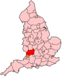
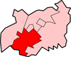
Stroud (district)
Contenu soumis à la licence CC-BY-SA. Source : Article Stroud (district) de Wikipédia en français (auteurs)
Regardez d'autres dictionnaires:
Stroud (district) — Stroud is a local government district in Gloucestershire, England. It is named after its largest town, Stroud, and has its administrative headquarters in Ebley Mill, in the Ebley area on the outskirts of the town. The district is mixed and… … Wikipedia
Stroud (District) — Stroud District Lage in Gloucestershire Status District Region South West England Verw.grafschaft Gloucestershire … Deutsch Wikipedia
District de Stroud — Stroud (district) Stroud Statut District non métropolitain Géographie … Wikipédia en Français
Stroud (disambiguation) — Stroud may mean:Place namesIn Australia: *Stroud, New South WalesIn Canada: *Stroud, OntarioIn England: *Stroud, Gloucestershire *Stroud (district), Gloucestershire *Stroud (UK Parliament constituency) *Stroud, Hampshire, near Petersfield *Stroud … Wikipedia
Stroud (Begriffsklärung) — Stroud ist der Name Stroud (District) ein Distrikt in der englischen Grafschaft Gloucestershire Stroud ine englische Ortschaft Verwaltungssitz des obigen Distriktes Stroud (New South Wales) einer australischen Ortschaft in New South Wales Stroud… … Deutsch Wikipedia
Stroud, Gloucestershire — infobox UK place country = England official name= Stroud latitude= 51.7443 longitude= 2.2151 civil parish= Stroud population = 12,690 [UK 2001 census data for Stroud Civil Parish. Source: [http://neighbourhood.statistics.gov.uk/dissemination/LeadT… … Wikipedia
stroud — /strowd/, n. a coarse woolen cloth, blanket, or garment formerly used by the British in bartering with the North American Indians. [1670 80; named after Stroud in Gloucestershire, England, where woolens are made] * * * ▪ district, England, United … Universalium
Stroud News & Journal — The Stroud News Journal is a weekly paid for newspaper based in Stroud, Gloucestershire. It is published every Wednesday in a tabloid format by Newsquest and covers a large portion of the Stroud district, including the towns of Stroud,… … Wikipedia
Stroud (UK Parliament constituency) — UK constituency infobox Name = Stroud Map1 = Stroud Map2 = Gloucestershire Entity = Gloucestershire Type = County County = Gloucestershire Year = 1832, 1955 MP = David Drew Party = Labour Co operative EP = South West England Stroud is a county… … Wikipedia
Stroud Green Road — is in north London, forming part of the boundary between the London Borough of Islington on its southern side and the London Borough of Haringey on the northern side. (Grid reference: mmukscaled|TQ311871|10|TQ 311 871.) It is not widely known… … Wikipedia
 Royaume-Uni
