- Assirik
-
Mont Assirik
Mont Assirik 
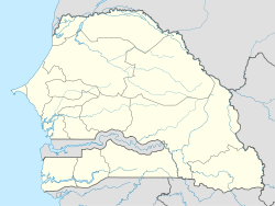
Géographie Altitude 311 m Massif Monts Bassari Longueur km Largeur km Superficie km2 Coordonnées Administration Pays  Sénégal
Région Subdivision Géologie Âge Roches Géolocalisation sur la carte : Sénégal modifier 
Le mont Assirik est le point culminant (311 mètres) du parc national du Niokolo-Koba au Sénégal.
C'est un refuge pour de nombreuses espèces en voie de disparition. Les derniers éléphants du Sénégal ont trouvé refuge dans ce sanctuaire ainsi que les élands de Derby (la plus grande antilope au monde).
Voir aussi
Bibliographie
- Wiese, Bernd: Senegal, Gambia: Länder der Sahel-Sudan-Zone Klett-Perthes Verlag, Gotha, Germany, ISBN 3-623-00664-5
- Stella Margaret Brewer: The chimps of Mt. Asserik Knopf : distributed by Random House, 1978, ISBN 0394494490
- Anderson, J. R. & McGrew, W. C. (1984). Guinea baboons (Papio papio) at a sleeping site. Am. J. Primatol. 6: 1-14.
- Baldwin, P. J. (1979). The natural history of the chimpanzee (Pan troglodytes verus) at Mt. Assirik, Senegal. Ph. D. thesis, Stirling University.
- Baldwin, P. J., McGrew, W. C. & Tutin, C. E. G. (1982). Wide-ranging chimpanzees at Mt. Assirik, Senegal. Int. J. Primatol. 3: 367-385.
- Baldwin, P. J., Sabater Pi, J., McGrew, W. C. & Tutin, C. E. G. (1981). Comparisons of nests made by different populations of chimpanzees (Pan troglodytes). Primates. 22: 474-486.
- Bermejo, M., Illera, G. & Sabater Pi, J. (1989). New observations on the tool-behavior of chimpanzees from Mt. Assirik (Senegal, West Africa). Primates. 30: 65-73.
- Brewer, S. (1978). The Chimps of Mt. Assirik. New York: Knopf.
- Harrison, M. J. S. (1984). Patterns of range use by the green monkey, Cercopithecus sabaeus, at Mt. Assirik, SenegaFolia primatol. 41: 157-179.
- Kortlandt, A. (1983). Marginal habitats of chimpanzeesJ. Hum. Evol. 12: 231-278.
- Kortlandt, A. (1983). Reply to McGrew, Baldwin & Tutin. J. Hum. Evol. 12: 415-417.
- McBeath, N. M. & McGrew, W. C. (1982). Tools used by wild chimpanzees to obtain termites at Mt. Assirik, Senegal: The influence of habitat. J. Hum. Evol. 11: 65-72.
- McGrew, W. C., Baldwin, P. J. & Tutin, C. E. G. (1981). Chimpanzees in a hot, dry and open habitat: Mt. Assirik, Senegal, West Africa. J. Hum. Evol. 10: 227-244.
- McGrew, W. C., Baldwin, P. J. & Tutin, C. E. G. (1983). A reply to Kortlandt's "Marginal habitats of chimpanzees". J. Hum. Evol. 12: 413-417.
- McGrew, W. C., Baldwin, P. J. & Tutin, C. E. G. (1988). Diet of wild chimpanzees (Pan troglodytes verus) at Mt. Assirik, Senegal: I. Composition. Am. J. Primatol. 16: 213-226.
- McGrew, W. C., Sharman, M. J., Baldwin, P. J. & Tutin, C. E. G. (1982). On early hominid plant-food niches. Curr. Anthropol. 23: 213-214.
- McGrew, W. C., Tutin, C. E. G., Baldwin, P. J., Sharman, M. J. & Whiten, A. (1978). Primates preying on vertebrates: new records from West Africa (Pan troglodytes verus, Papio papio, Cercopithecus sabaeus). Carnivore. 1: 41-45.
- McGrew, W. C., Tutin, C. E. G., Collins, D. A. & File, S. K. (1989). Intestinal parasites of sympatric Pan troglodytes and Papio spp. at two sites: Gombe (Tanzania) and Mt. Assirik (Senegal). Am. J. Primatol. 17: 147-155.
- Sharman, M. J. (1981). Feeding, ranging and social organization of the guinea baboon. Ph. D. thesis, University of St. Andrews.
- Tutin, C. E. G., McGrew, W. C. & Baldwin, P. J. (1981). Responses of wild chimpanzees to potential predators. pp. 136-141 IN Chiarelli, A. B. & Corruccini, R. S. (Ed.), Primate Behavior and Sociobiology. New York: Springer-Verlag.
- Tutin, C. E. G., McGrew, W. C. & Baldwin, P. J. (1983). Social organization of savanna-dwelling chimpanzees, Pan troglodytes verus, at Mt. Assirik, Senegal. Primates. 24: 154-173.
Liens externes
- Portail de la montagne
- Portail du Sénégal
Catégories : Montagne du Sénégal | Sommet d'Afrique
Wikimedia Foundation. 2010.

