Postavaru
- Postavaru
-
Postăvaru
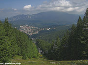
Le massif Postavaru est un massif de Roumanie, partie intégrante des Carpates. Il domine, entre autres, la station de sports d'hiver de Predeal.

Predeal et le mont Postavaru
 Portail de la Roumanie
Catégories : Roumanie | Montagne de Roumanie
Wikimedia Foundation.
2010.
Contenu soumis à la licence CC-BY-SA. Source : Article Postavaru de Wikipédia en français (auteurs)
Regardez d'autres dictionnaires:
Postăvaru — 45° 30′ N 25° 30′ E / 45.5, 25.5 … Wikipédia en Français
Valea Postăvaru River — Geobox River name = Valea Postăvaru River native name = other name = other name1 = image size = image caption = country type = Countries state type = region type = district type = Counties city type = Villages country = Romania country1 = state … Wikipedia
Poiana Braşov — Infobox ski area name= Poiana Braşov picture= caption= location= Mt. Postavaru, Romania nearest city= Braşov lat degrees= 45 lat minutes= 35 lat seconds= 50 lat direction= N long degrees= 25 long minutes= 33 long seconds= 07 long direction= E top … Wikipedia
Tâmpa, Braşov — Infobox Mountain Name = Tâmpa Photo =Tampabv.jpg Caption = Elevation = 960 m (3,150 ft) Location = Braşov, Romania Range = Curved Carpathians, Eastern Carpathians Prominence = 350 m Coordinates = coord|45|38|N|25|35|E|type:mountain Topographic… … Wikipedia
Valea Calului River (Timiş) — Geobox River name = Valea Calului River native name = other name = other name1 = image size = image caption = country type = Countries state type = region type = district type = Counties city type = Villages country = Romania country1 = state =… … Wikipedia
Timiş River (Olt) — Geobox River name = Timiş River native name = other name = (Timişul Sec River) other name1 = image size = image caption = country type = Countries state type = region type = district type = Counties city type = Villages country = Romania country1 … Wikipedia
Pârâul Rece (Ghimbăşel) — Geobox River name = Pârâul Rece native name = other name = other name1 = image size = image caption = country type = Countries state type = region type = district type = Counties city type = Villages country = Romania country1 = state = state1 =… … Wikipedia
Predeal — Vue aérienne de la station. Administration Pays Roumanie Géographie … Wikipédia en Français
Transylvanian Mountains — is the general name of the mountain system that surrounds the Transylvanian highland or plateau on all four sides, and forms the southeastern and southern continuation of the Carpathian Mountains. At the mouths of the Vişeu River and the Golden… … Wikipedia
Vlădeţul Mijlociu River — Geobox River name = Vlădeţul Mijlociu River native name = other name = other name1 = image size = image caption = country type = Countries state type = region type = district type = Counties city type = Villages country = Romania country1 = state … Wikipedia

 Roumanie

