Pink Cliffs

Pink Cliffs

37°31′N 112°15.7′W / 37.517, -112.2617

Les Pink Cliffs (Falaises roses) sont une suite de hautes falaises localisées en bordure du plateau de Paunsaugunt au sud-ouest de l'Utah aux États-Unis. Une grande partie de ces falaises sont protégées au sein du parc national de Bryce Canyon.

Les falaises s'étendent sur environ 56 km le long de la limite sud-est du plateau de Paunsaugunt. Ce plateau est un des sous plateaux élevés appartenant au plateau du Colorado.

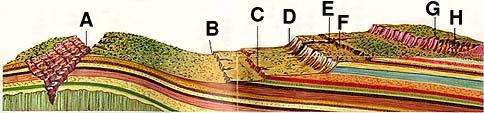
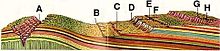
Grand Canyon (A), Chocolate Cliffs (B), Vermilion Cliffs (C), White Cliffs (D), Zion Canyon (E), Gray Cliffs (F), Pink Cliffs (G), Bryce Canyon (H)

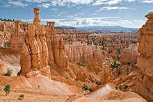
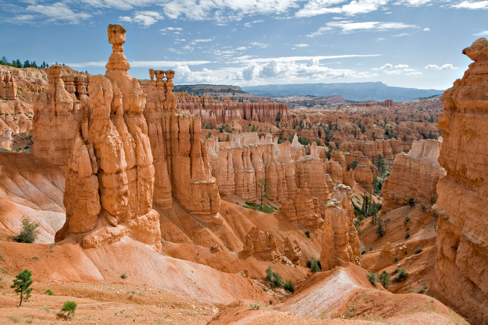
Les roches ont des colorations rougeâtre et rosâtre et appartiennent à la formation géologique de Claron. La coloration des roches provient de la présence d'un oxyde de fer appelé hématite. Cette formation constitue la couche géologique supérieure du parc national de Bryce Canyon et est composée de roches sédimentaires calcaires. La formation de Claron est également la couche géologique supérieure du Grand Staircase qui s'étend jusqu'au Grand Canyon en Arizona. C'est dans cette formation géologique que les hoodoos se forment dans Bryce Canyon.

Hoodoos formé dans les Pink Cliffs

Voir aussi

Lien interne

Lien externe


Wikimedia Foundation. 2010.

Contenu soumis à la licence CC-BY-SA. Source : Article Pink Cliffs de Wikipédia en français (auteurs)

Игры ⚽ Нужна курсовая?

Regardez d'autres dictionnaires:

  • Pink Cliffs — The Pink Cliffs are series of highly dissected cliffs, approximately 35 mi (56 km) long, along the southeast edge of the Paunsaugunt Plateau in southwestern Utah in the United States. The cliffs form unique rock formations and are largely… …   Wikipedia

  • Pink film — ] Though the appearance of the AV (adult video) took away most of the pink film audience in the 1980s, films in this genre are still being produced.Description of the pink film The eroductions are the limpest of softcore, and though there is much …   Wikipedia

  • Utah Cliffs Loop Bicycle Route — The Adventure Cycling Association Utah Cliffs Loop Bicycle Route is a loop rather than a point to point route. Southwestern Utah is known by many as Color Country. Riders will discover how apt this nickname is as they encounter the rich hues of… …   Wikipedia

  • Coral Pink Sand Dunes State Park — Coordinates: 37°2′16″N 112°43′13″W / 37.03778°N 112.72028°W / 37.03778; 112.72028 …   Wikipedia

  • cheddar pink — noun mat forming perennial of central Europe with large fragrant pink or red flowers • Syn: ↑Diangus gratianopolitanus • Hypernyms: ↑pink, ↑garden pink * * * noun Usage: usually capitalized C Etymology …   Useful english dictionary

  • Geology of the Bryce Canyon area — Paria View overlooks an intermittent stream flowing toward the Paria River, s …   Wikipedia

  • Colorado Plateau — A map of the Colorado Plateau. The …   Wikipedia

  • Grand Staircase — Der Cockscomb (Hahnenkamm) verläuft entlang der Cottonwood Canyon Road Die Grand Staircase (Große Treppe) ist eine in Form einer großen Treppe angeordnete Abfolge von Sedimentschichten in den Vereinigten Staaten, die sich in den Bundesstaaten… …   Deutsch Wikipedia

  • Bryce Canyon — Nationalpark Erosionsformen im Bryce Canyon …   Deutsch Wikipedia

  • Bryce Canyon National Park — Bryce Canyon Nationalpark Erosionsformen im Bryce Canyon …   Deutsch Wikipedia

Share the article and excerpts

Direct link
Do a right-click on the link above
and select “Copy Link”