- Pennsylvania Canal (North Branch Division)
-
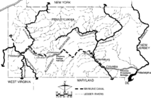 Ancien réseau navigable en Pennsylvanie.
Le North Branch Division of the Pennsylvania Canal était un canal qui s’étirait sur 271 km entre les villes de Northumberland et d’Athens en Pennsylvanie aux États-Unis.
Sommaire
Description
Près de la ville de Northumberland, le canal débutait son tracé au niveau de la confluence entre les rivières North Branch Susquehanna River et West Branch Susquehanna River. Ces deux rivières sont des affluents du fleuve Susquehanna. Le canal était au total équipé de 43 écluses ce qui permettait aux bateaux de gravir au total un dénivelé d’environ 100 mètres[1].
Au nord, le canal se terminait près d’Athens à la frontière entre l’État de Pennsylvanie et l’État de New York. Dans ce dernier état, le canal était prolongé en tant que Junction Canal. Ce canal était un canal de 29 km construit par des investisseurs privés. Il était relié au North Branch Canal près de la ville d’ Elmira. Près d’Athens, le canal était également relié au Canal Chemung qui était de son côté relié au canal Érié. Grâce à cet ensemble de canaux, il était possible de relier la ville de Buffalo au lac Champlain[1].
Au sud, du côté de Northumberland, le canal était relié au canal de Pennsylvanie (Pennsylvania Canal) et faisaient partie d’un système navigable plus global comprenant le Main Line of Public Works.
Histoire
Les travaux du premier tronçon du canal, long de 88 km, ont débuté en 1828 pour se terminer en 1831 au niveau de la localité de Nanticoke Falls. En 1834, le canal fut allongé de 27 km. Les travaux du dernier tronçon, long de 156 km, eurent lieu entre 1836 et 1856[1].
Vestiges
Le canal n’est plus en activité au XXIe siècle. Il subsiste toutefois quelques tronçons et quelques écluses. Près de Wilkes-Barre, les vestiges sont visibles près d’un sentier pédestre d’environ 1 km de long[2].
L’écluse n°1 et une section du canal restèrent intactes jusque 1986. Des portions du lit du canal sont toujours visibles entre Shickshinny et West Nanticoke. La porte de garde de West Nanticoke était toujours intacte. Des tronçons étaient aussi visibles de la Lackawanna River jusque Ransom. À Laceyville, une maison d’éclusier a été transformée en musée[3].
Voir aussi
Bibliographie
- (en)Petrillo, F. Charles (1986). Anthracite and Slackwater: The North Branch Canal 1828–1901. Easton, Pennsylvania: Center for Canal History and Technology. ISBN 0-930973-04-6.
- (en)Shank, William H. (1981). The Amazing Pennsylvania Canals, 150th Anniversary Edition. York, Pennsylvania: American Canal and Transportation Center. ISBN 0-933788-37-1.
Références
- (en) Cet article est partiellement ou en totalité issu de l’article de Wikipédia en anglais intitulé « Pennsylvania Canal (North Branch Division) » (voir la liste des auteurs)
- (en)Shank (1981), pp. 51-52
- (en)Introduction to Pennsylvania's Historic Canals, Pennsylvania Canal Society. Consulté le 26-11-2007
- (en)Petrillo (1986), pp. 237-242
 Portail de l’eau
 Portail du bâtiment et des travaux publics
 Portail des États-Unis
 Portail du monde maritime
Catégories :- Canal des États-Unis
- Canal du XIXe siècle

Wikimedia Foundation. 2010.