Paragould
- Paragould
-
36° 03′ 25″ N 90° 30′ 11″ W / 36.056944, -90.503056
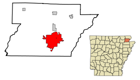
La ville de Paragould est le siège du comté de Greene, dans l’État de l’Arkansas, aux États-Unis. Selon le recensement de 2006, sa population s’élève à 23 775 habitants. Densité : 122,7 hab./km² (317,7 hab./mi²). Superficie totale : 80,2 km² (31 mi²).
Histoire
Le nom de la ville regroupe les noms de J. W. Paramore et Jason Gould, propriétaires de deux lignes de chemin de fer qui se croisaient à cet endroit. Paragould a été incorporée le 3 mars 1883. Son nom s’est également écrit Para-Gould et ParaGould.
Lien externe
Source
Wikimedia Foundation.
2010.
Contenu soumis à la licence CC-BY-SA. Source : Article Paragould de Wikipédia en français (auteurs)
Regardez d'autres dictionnaires:
Paragould — Paragould, AR U.S. city in Arkansas Population (2000): 22017 Housing Units (2000): 9789 Land area (2000): 30.812064 sq. miles (79.802876 sq. km) Water area (2000): 0.157449 sq. miles (0.407790 sq. km) Total area (2000): 30.969513 sq. miles… … StarDict's U.S. Gazetteer Places
Paragould, AR — U.S. city in Arkansas Population (2000): 22017 Housing Units (2000): 9789 Land area (2000): 30.812064 sq. miles (79.802876 sq. km) Water area (2000): 0.157449 sq. miles (0.407790 sq. km) Total area (2000): 30.969513 sq. miles (80.210666 sq. km)… … StarDict's U.S. Gazetteer Places
Paragould — Dieser Artikel wurde aufgrund von inhaltlichen Mängeln auf der Qualitätssicherungsseite des Projektes USA eingetragen. Hilf mit, die Qualität dieses Artikels auf ein akzeptables Niveau zu bringen, und beteilige dich an der Diskussion! … Deutsch Wikipedia
Paragould — Original name in latin Paragould Name in other language PGR State code US Continent/City America/Chicago longitude 36.0584 latitude 90.49733 altitude 96 Population 26113 Date 2011 05 14 … Cities with a population over 1000 database
Paragould — Sp Pãraguldas Ap Paragould L JAV Grino apyg. c. (Arkanzasas) … Pasaulio vietovardžiai. Internetinė duomenų bazė
Paragould High School — is a public school serving grades nine through twelve located in Paragould, Arkansas. The campus is located at 1701 West Court Street in Paragould and is administered by the Paragould School District.The school s mascot is the Ram. The Pargould… … Wikipedia
Paragould (Arkansas) — Paragould Paragould Pays États Unis État … Wikipédia en Français
Paragould School District — is a public school district located in Paragould, Arkansas. The district includes numerous campuses, including the Paragould Secondary Complex (which includes Paragould High School and Paragould Junior High School), the Oak Grove Heights campus… … Wikipedia
Paragould, Arkansas — Infobox Settlement official name = Paragould, Arkansas settlement type = City imagesize = image caption = image imagesize = image caption = image mapsize = 250px map caption = Location in Greene County and the state of Arkansas mapsize1 = map… … Wikipedia
Paragould meteorite — The Paragould Meteorite at 16 by 41 inches (406 by 1041 mm) and weighs 816 pounds (370 kg) is the second largest stony meteorite ever recovered in North America and the largest chondrite. It fell to Earth at approximately 4:08 a.m. on February 17 … Wikipedia
 États-Unis
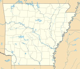
 Arkansas