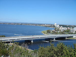
Narrows Bridge (Perth)
- Narrows Bridge (Perth)
-
Le Narrows Bridge est un pont autoroutier traversant le fleuve Swan, à Perth en Australie-Occidentale, dans le quartier des The Narrows entre Mill Point et Mont Eliza. Constitué de deux ponts routiers et d'un pont ferroviaire, il relie les autoroutes Mitchell et Kwinana, reliant le centre ville au nord à la banlieue au sud. Le premier pont routier a été ouvert en 1959 et était le plus grand pont en béton préfabriqué et précontraint au monde. Les autres ponts ont été ajoutés dans les années 2000 par suite de la croissance des volumes de trafic en ville.
Wikimedia Foundation.
2010.
Contenu soumis à la licence CC-BY-SA. Source : Article Narrows Bridge (Perth) de Wikipédia en français (auteurs)
Regardez d'autres dictionnaires:
Narrows Bridge (Perth) — The Narrows Bridge seen prior to the completion of the railway line The Narrows Bridge is a freeway crossing of the Swan River in Perth, Western Australia, at The Narrows between Mill Point and Mount Eliza. Made up of two road bridges and a… … Wikipedia
Narrows Bridge — may refer to: Narrows Bridge (Perth), Western Australia Narrows Bridge (Indiana), USA See also Tacoma Narrows Bridge, pair of suspension bridges in Tacoma, Washington, USA Tacoma Narrows Bridge (1940), the first suspension bridge in Tacoma,… … Wikipedia
Narrows Bridge — /næroʊz ˈbrɪdʒ/ (say narohz brij) noun a bridge across the Swan River, Perth, completed in 1959 …
Perth Water — is the section of the Swan River between the Causeway to the east, and Narrows Bridge to the west a large wide but shallow section of river on the southern edge of the City of Perth, Western Australia, and the northern edge of the suburb South… … Wikipedia
South Perth, Western Australia — Infobox Australian Place | type = suburb name=South Perth city=Perth state=wa caption=South Perth viewed from Kings Park, the large area of trees on the right is the Zoo with St Mary s Church behind. lga=City of South Perth area=5.2 postcode=6151 … Wikipedia
Mount Henry Bridge — The Mount Henry Bridge carries the Kwinana Freeway and Mandurah railway line over the Canning River in Perth, Western Australia, approximately 10 kilometres (6.2 mi) south of the Perth central business district. At 660 metres… … Wikipedia
Mandurah railway line, Perth — The Mandurah Railway Line is an interurban railway line, running through the south western suburbs of Perth, Western Australia. Partly located in the median of the Kwinana Freeway, the line connects Perth with Western Australia s second largest… … Wikipedia
History of Perth, Western Australia — This article details the History of Perth from the first human activity in the region to the 20th century. The article covers aspects of all of the Perth metropolitan area, including the modern CBD. The city of Perth in Western Australia was… … Wikipedia
List of Perth landmarks — This page consists of many of Perth, Western Australia landmarks. Landmarks constitute man made structures, or natural features that literally command the horizon physically, or the cultural landscape, usually by historical or political… … Wikipedia
Old Mill, Perth — For other uses, see Old Mill (disambiguation). Old Mill, Perth Old Mill buildings Origin Mill name Old Mill, Shento … Wikipedia


