Milperra (Nouvelle-Galles-du-Sud)
- Milperra (Nouvelle-Galles-du-Sud)
-
Milperra (Nouvelle-Galles-du-Sud)
33° 56′ 34″ S 150° 58′ 49″ E / -33.94282, 150.98037
Milperra est une ville de la banlieue de Sydney en Nouvelle-Galles du Sud, située à 24 km au sud-ouest de Sydney et peuplée d’environ 4 000 habitants.
C'est à la fois une ville résidentielle, commerciale et industrielle.
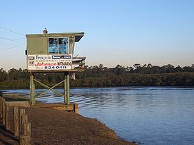
Milperra se trouve sur les berges de la Georges River et elle compte nombre de parcs et de réserves le long de la rivière, dont Deepwater Park, Riverlands Golf Course et Vale of Ah Reserve.
La ville compte comme personnalité le nageur Ian Thorpe, né à Milperra.
Sources
 Portail de l’Australie
Catégorie : Banlieue de Sydney
Wikimedia Foundation.
2010.
Contenu soumis à la licence CC-BY-SA. Source : Article Milperra (Nouvelle-Galles-du-Sud) de Wikipédia en français (auteurs)
Regardez d'autres dictionnaires:
Milperra — 33° 56′ 34″ S 150° 58′ 49″ E / 33.94282, 150.98037 … Wikipédia en Français
Contenu:Australie — Projet:Australie/Liste des articles Liste mise à jour régulièrement par MyBot (d · c · b) à partir des articles liés au bandeau {{Portail Australie}} Modifications récentes des articles ayant le bandeau de ce portail… … Wikipédia en Français
University of Western Sydney — Devise Bringing knowledge to life Informations Fondation 1989 Type Établissement public Vice chancelier … Wikipédia en Français
Université occidentale de Sydney — University of Western Sydney Devise Bringing knowledge to life Informations Fondation 1989 Type Établissement public Régime linguistiq … Wikipédia en Français
Ville de Bankstown — 33° 55′ 00″ S 151° 02′ 00″ E / 33.916667, 151.033333 … Wikipédia en Français
Bankstown — L Appian Way à Bankstown Administration Pays … Wikipédia en Français
Bass Hill — Cinéma en plein air de Bass Hill Administration … Wikipédia en Français
Birrong — Auburn Road, Birrong Administration Pays … Wikipédia en Français
Chester Hill — Nugent Park, Chester Hill Administration Pays … Wikipédia en Français
Condell Park — Soirée devant le centre commercial de Condell Park Administration … Wikipédia en Français
 Australie
