Mare Humboldtianum
- Mare Humboldtianum
-
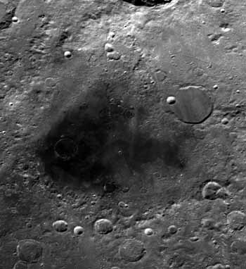
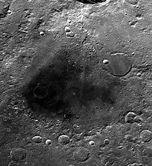
Mare Humboldtianum ("mer d'Alexander von Humboldt, en Latin") est une mare lunaire situé dans le bassin Humboldtianum, immédiatement à l'Est de Mare Frigoris. Elle est située sur la bordure Nord-Est du disque lunaire est chevauche la face visible et la face cachée de la lune. Du fait de cette position, son observation est dépendante des librations. Dans certaines occasions, Mare Humboldtianum n'est pas visible depuis la terre.
Le matériau du bassin remonte à l'ère du nectarien, tandis que le matériau de la mer elle-même remonte à l'imbrien supérieur. La partie Sud-Est du bassin, d'un gris plus léger, est une région de collines.
Les coordonnées sélénographiques de cette mer sont 56.8° N, 81.5° E, son diamètre est de 273 km. Le bassin fait lui-même 600 km. Bel'kovich est un cratère notable de cette mer.
Cette mer fut baptisée ainsi par Johann H. Mädler d'après Alexander von Humboldt, en reconnaissance de ses explorations des terres inconnues. Avec Mare Smythii, il s'agit de la seule mer nommée d'après un individu.
Voir aussi
Lien externe
Wikimedia Foundation.
2010.
Contenu soumis à la licence CC-BY-SA. Source : Article Mare Humboldtianum de Wikipédia en français (auteurs)
Regardez d'autres dictionnaires:
Mare Humboldtianum — (NASA Aufnahme) Das Mare Humboldtianum (Lat. „Humboldt Meer“) ist ein Mondmeer des Erdmondes innerhalb des Humboldtianum Beckens östlich des Mare Frigoris. Es befindet sich auf den selenographischen Koordinaten 56,8° N, 81,5° E und weist einen… … Deutsch Wikipedia
Mare Humboldtianum — is the dark patch at the center. The upper left is occupied by the walled plain Bel kovich. NASA image. Coordinates … Wikipedia
Mare Humboldtianum — El Mare es la mancha oscura al centro de la imagen. La zona superior izquierda es ocupada por el cráter Bel kovich. Coordenadas 56.8° N, 81.5° E … Wikipedia Español
Mare Moscoviense — Coordinates … Wikipedia
Mare Serenitatis — Photograph of Mare Serenitatis Coordinates … Wikipedia
Mare Imbrium — A map showing the location of Mare Imbrium Coordinates … Wikipedia
Mare Insularum — Mare Insularum, bordered by the craters Copernicus on the east, and Kepler on the west. Oceanus Procellarum joins the mare to the southwest. The northern edge of Mare Cognitum is visible at the bottom of the photo, and Fra Mauro is the grey patch … Wikipedia
Mare Nectaris — Coordinates … Wikipedia
Mare Vaporum — Mare Vaporum. The crater Manilius can be seen as the bright circular object to the right of the mare. To the south Rima Hyginus is visible as a light colored thin line. In the upper left hand side of the photo is the mountain range Montes… … Wikipedia
Mare Orientale — Close up view of Mare Orientale Coordinates … Wikipedia
 Mare Humboldtianum