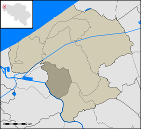
Mannekensvere

Mannekensvere

Wikimedia Foundation. 2010.

Contenu soumis à la licence CC-BY-SA. Source : Article Mannekensvere de Wikipédia en français (auteurs)

Игры ⚽ Поможем решить контрольную работу

Regardez d'autres dictionnaires:

  • Mannekensvere —   Deelgemeente   Coordinates …   Wikipedia

  • Middelkerke — Middelkerke …   Deutsch Wikipedia

  • Middelkerke —   Middelkerke Géolocalisation sur la carte : Belgique …   Wikipédia en Français

  • Middelkerke — Flag …   Wikipedia

  • Nieuwpoort, Belgium — Nieuwpoort Belfry and city hall …   Wikipedia

  • List of postal codes in Belgium — Belgian postal codes are numeric and consist of 4 numbers, although the last one is often zero. The first digit indicates the province (except for the 3xxx numbers that are shared by the eastern part of Flemish Brabant and Limburg and the and… …   Wikipedia

  • Postleitzahl (Belgien) — Postleitzahlen Gebiete in Belgien nach den ersten beiden Stellen Inhaltsverzeichnis 1 1 Region Brüssel Hauptstadt / Wallonisch Brabant / Flämisch Bra …   Deutsch Wikipedia

  • A18 (Belgique) — Autoroute belge A18 Autoroute belge A18 Longueur : 40 km …   Wikipédia en Français

  • Arrondissement Administratif D'Ostende —   Arrondissement d’Ostende …   Wikipédia en Français

  • Arrondissement administratif d'Ostende — 51° 12′ N 2° 54′ E / 51.2, 2.9 …   Wikipédia en Français

Share the article and excerpts

Direct link
Do a right-click on the link above
and select “Copy Link”