Lunga (Treshnish Isles)
- Lunga (Treshnish Isles)
-
Lunga (Treshnish Isles)

Pour les articles homonymes, voir
Lunga.
Lunga est une île du Royaume-Uni située en Écosse. C'est la plus grandes des Treshnish Isles.
Histoire
D'origine volcanique, Lunga à été décrit comme un « joyaux vert dans une mère de paon ». Peuplée jusqu'au XIXe siècle, Lunga porte encore les vestiges de maisons noires. Au nord-est de l'île se trouvent les restes du village en ruine qui fut abandonné en 1857.
Faune et flore
Lunga est site d'intérêt scientifique en raison de sa flore abondante.
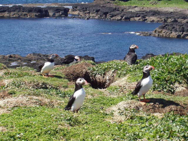
Les phoques gris vivent dans les eaux entourant l'île tandis que La faune ornithologique comprend l'océanite, la mouette tridactyle, le macareux, etc.
 Portail de l’Écosse
 Portail du monde maritime
Catégories : Île des Hébrides intérieures | Île de la mer des Hébrides | Île inhabitée
Wikimedia Foundation.
2010.
Contenu soumis à la licence CC-BY-SA. Source : Article Lunga (Treshnish Isles) de Wikipédia en français (auteurs)
Regardez d'autres dictionnaires:
Lunga, Treshnish Isles — Infobox Scottish island | latitude=56.49 longitude= 6.42 GridReference=NM278419 celtic name=Lungaigh norse name=langr øy meaning of name= (long)ship island , from Norse area=81 ha area rank= 159 highest elevation=Cruachan 103 m Population=0… … Wikipedia
Treshnish Isles — Géographie Pays Royaume Uni Localisation Mer des Hébrides (océan Atlantique) C … Wikipédia en Français
Treshnish Isles — von der Isle of Mull aus gesehen Gewässer Atlantischer Ozean … Deutsch Wikipedia
Treshnish Isles — The Treshnish Isles is an archipelago of small islands and skerries, lying west of Mull, in Scotland. They are part of the Inner Hebrides. From north to south, the larger islands include:* Cairn na Burgh Beag * Cairn na Burgh Mòr * Fladda * Sgeir … Wikipedia
Lunga — There are a number of places called Lunga, namely:Two islands in Scotland: * Lunga (Treshnish Isles), the largest of the Treshnish Isles at 81ha in size, located at gbmapping|NM275415 * Lunga, Firth of Lorn, in the Sound of Luing, north of Scarba … Wikipedia
Treshnish — Isles Treshnish Isles Géographie Pays Royaume Uni Localisation Mer des Hébrides (océan Atlantique) C … Wikipédia en Français
Lunga (îles Treshnish) — Pour les articles homonymes, voir Lunga. Lunga Lungaigh (gd) … Wikipédia en Français
Îles Treshnish — Treshnish Islands (en) Bac Beag (à gauche) et Bac Mòr (à droite) … Wikipédia en Français
Islas Treshnish — (Na h Eileanan Samhraidh Summer Isles) Las islas Treshnish desde el Puerto Haunn en la isla de Mull … Wikipedia Español
Список островов Шотландии — Карта Внешних и Внутренних Гебрид Этот список содержит перечисление морских и пресноводных островов Шотландии (континентальная часть которой является частью острова Великобритания). Помимо того, в список включены связанные с рас … Википедия
 Royaume-Uni
 Lunga
Lunga Macareux sur Lunga.