Lugnaquilla
- Lugnaquilla
-
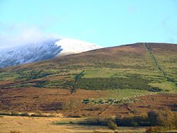
Lugnaquilla (Log na Coille) est une montagne située dans le comté de Wicklow dans l'est de l'Irlande. C'est le point culminant des montagnes de Wicklow, avec 926 mètres de hauteur.
Sa proximité de Dublin en fait un des sites montagneux les plus visités.
Voir aussi
Articles connexes
Liens externes
Wikimedia Foundation.
2010.
Contenu soumis à la licence CC-BY-SA. Source : Article Lugnaquilla de Wikipédia en français (auteurs)
Regardez d'autres dictionnaires:
Lugnaquilla — Infobox Mountain Name=Lugnaquilla Log na Coille Photo = Peaklug.jpg Caption = Lugnaquilla as seen from Camara Hill Elevation=925 m (3,035 ft) Location=Wicklow, IRL Range = Wicklow Mountains Prominence=838 m Ranked 21st in Ireland and Great… … Wikipedia
Lugnaquilla — Wicklow Mountains Die Wicklow Mountains (irisch Sléibhte Chill Mhantáin) sind ein Gebirgszug im Osten und Südosten von Irland. Sie verlaufen in Nord Süd Richtung, direkt vom Süden Dublins über die Grafschaft Wicklow in die Grafschaft Wexford … Deutsch Wikipedia
Lugnaquilla Mountain — Sp Lagnakilos kálnas Ap Lugnaquilla Mountain angliškai L Airijoje … Pasaulio vietovardžiai. Internetinė duomenų bazė
Wicklow Mountains — Coordinates: 53°04′52″N 6°23′24″W / 53.08111°N 6.39°W / 53.08111; 6.39 … Wikipedia
Mullaghcleevaun — Wicklow Mountains Die Wicklow Mountains (irisch Sléibhte Chill Mhantáin) sind ein Gebirgszug im Osten und Südosten von Irland. Sie verlaufen in Nord Süd Richtung, direkt vom Süden Dublins über die Grafschaft Wicklow in die Grafschaft Wexford … Deutsch Wikipedia
Wicklow Mountains — p1p5 Wicklow Mountains Sléibhte Chill Mhantáin Wicklow Mountains Höchster Gipfel Lugnaquilla ( … Deutsch Wikipedia
Montagnes de Wicklow — Géographie Altitude 925 m, Lugnaquilla Longueur 66 km Largeur … Wikipédia en Français
Glen of Imaal — The Glen of Imaal ( ga. Gleann Uí Mháil) is a remote valley in the western Wicklow Mountains, ringed by the Lugnaquilla massif and its foothills, including Table mountain and Keadeen. Much of the Glen is used by the Irish Army as an artillery… … Wikipedia
Donard — Not to be confused with Slieve Donard. Donard Dún Ard Town … Wikipedia
County Wicklow — Contae Chill Mhantáin Coat of arms Motto … Wikipedia
 Irlande


