Lincoln Highway
- Lincoln Highway
-
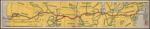
La Lincoln Highway est la plus ancienne route transcontinentale d'Amérique et la première construite pour les véhicules motorisés reliant les côtes Est et Ouest des États-Unis. L'entrepreneur Carl G. Fisher a été à l'origine du projet, dès septembre 1912. La route s'étendait sur 5 400 km[1] de Times Square à New York jusqu'au Lincoln Park de San Francisco, passait en 1928 dans 14 États (New York, New Jersey, Pennsylvanie, Ohio, Indiana, Illinois, Iowa, Nebraska, Colorado, Wyoming, Utah, Nevada, et Californie), et, au total, dans 128 comtés et plus de 500 villes et villages.
Notes et références
- ↑ Brian Butko, Greetings from the Lincoln Highway: America's First Coast-to-Coast Road Mechanicsburg, PA: Stackpole Books, 2005
Voir aussi
Liens externes
Sur les autres projets Wikimedia :
Wikimedia Foundation.
2010.
Contenu soumis à la licence CC-BY-SA. Source : Article Lincoln Highway de Wikipédia en français (auteurs)
Regardez d'autres dictionnaires:
Lincoln Highway — For the Australian highway, see Lincoln Highway (Australia). Lincoln Highway … Wikipedia
Lincoln Highway — Karte des Lincoln Highways Der Lincoln Highway, erdacht 1913 von Carl G. Fisher, war die erste Straße in den USA, die Ost und Westküste verband. Er verlief vom Times Square, New York bis zum Lincoln Park, San Francisco und verband dabei… … Deutsch Wikipedia
Lincoln Highway Motel — (Matteson,США) Категория отеля: 1 звездочный отель Адрес: 5200 West Lincoln Highway, Mat … Каталог отелей
Lincoln Highway Bridge — bezeichnet mehrere gleichnamige, im NRHP gelistete, Objekte: Lincoln Highway Bridge (Iowa), ID Nr. 78001263 Lincoln Highway Bridge (Utah), ID Nr. 75001825 Diese Seite ist eine Begriffsklärung zur Unterscheidung mehrerer mit demse … Deutsch Wikipedia
Lincoln Highway (Omaha) — Infobox nrhp name = Lincoln Highway (Omaha) caption = Official Lincoln Highway marker. location= Omaha, NE area = built = 1913 architecture= added = 2003 governing body = City of Omaha refnum=03000104 [… … Wikipedia
Lincoln Highway (Australien) — Blick auf Whyalla am Lincoln Highway Der Lincoln Highway ist eine Fernverkehrsstraße in South Australia, Australien. Er verläuft über eine Länge von 330 Kilometern entlang der östlichen Küstenlinie der Eyre Halbinsel und verbindet die Städte Port … Deutsch Wikipedia
Lincoln Highway (Australia) — Infobox Australian Road road name = Lincoln Highway route route route photo = caption = Formerly length = 327 direction = Northeast Southwest start = finish = est = through = Whyalla, Cowell, Arno Bay, Tumby Bay route = exits = : There is also a… … Wikipedia
Route of the Lincoln Highway — The Lincoln Highway followed the following route:New YorkThe very short Lincoln Highway section in New York went west from Times Square on 42nd Street to the Weehawken Ferry. It was realigned down Broadway from which it turned right and passed… … Wikipedia
211th Street (Lincoln Highway) (Metra) — Infobox Station name=211th Street (Lincoln Highway) type=Metra regional rail image size= image caption= address=211th Street between Olympian Way Olympian Circle Matteson, IL coordinates= line=Rail color box|system=Metra|line=Metra Electric other … Wikipedia
Lincoln Park (San Francisco) — Lincoln Park in San Francisco, California was dedicated to President Abraham Lincoln in 1909 and includes about convert|100|acre|km2|1 of the northwestern corner of the San Francisco Peninsula. It is part of the Golden Gate National Recreation… … Wikipedia