Lamotrek

Lamotrek
Lamotrek
Lamutrek
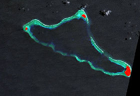
Image satellite de Lamotrek avec les îles en rouge.
Géographie
Pays Drapeau des États fédérés de Micronésie Micronésie
Archipel Îles Carolines
Localisation Océan Pacifique
Coordonnées 7° 22′ 00″ N 143° 54′ 00″ E / 7.366667, 143.97° 22′ 00″ N 143° 54′ 00″ E / 7.366667, 143.9
Superficie 1 km2
Nombre d'îles 3
Île(s) principale(s) Lamotrek
Géologie Atoll
Administration
Statut Municipalité

Drapeau des États fédérés de Micronésie Micronésie
État Yap
Démographie
Population 392 hab. (2008)
Densité 392 hab./km2
Autres informations
Fuseau horaire UTC+10

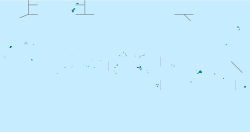
Géolocalisation sur la carte : Micronésie

(Voir situation sur carte : Micronésie)
Lamotrek
Lamotrek
Atolls des États fédérés de Micronésie

Lamotrek ou Lamutrek est un atoll des États fédérés de Micronésie situé dans les îles Carolines orientales, dans l'est de l'État de Yap[1] dont il constitue une municipalité[2]. L'atoll mesure un peu moins de 1 km2 de superficie[1] et comptait 392 habitants en 2008. La langue locale est un dialecte du woleai.

Notes et références

  1. a et b (en) Oceandots - Lamotrek. Consulté le 16 décembre 2010
  2. (en) Yap Branch Statistics Office, Division of Statistics, FSM Department of Economic Affairs, Yap State Census Report : 2000 FSM Census of Population and Housing, Government of the Federated States of Micronesia, décembre 2002, 232 p. [lire en ligne] 

Wikimedia Foundation. 2010.

Contenu soumis à la licence CC-BY-SA. Source : Article Lamotrek de Wikipédia en français (auteurs)

Игры ⚽ Поможем написать курсовую

Regardez d'autres dictionnaires:

  • Lamotrek — Vorlage:Infobox Insel/Wartung/Höhe fehlt Lamotrek Falschfarben Satellitenbild der NASA Gewässer Pazifik …   Deutsch Wikipedia

  • Lamotrek — Original name in latin Lamotrek Name in other language State code FM Continent/City Pacific/Chuuk longitude 7.491 latitude 146.305 altitude 9999 Population 0 Date 2011 01 12 …   Cities with a population over 1000 database

  • Lamotrek Municipality — Admin ASC 2 Code Orig. name Lamotrek Municipality Country and Admin Code FM.04.LA FM …   World countries Adminstrative division ASC I-II

  • Lamutrek — Lamotrek Lamotrek Lamutrek Géographie Pays  Micronésie Archipel Îles Carolines …   Wikipédia en Français

  • Fernost-Verband — Der Fernost Verband war ein Verband deutscher Kriegsschiffe, der im Zweiten Weltkrieg im Pazifik operierte. Kulmerland …   Deutsch Wikipedia

  • Pwo — is a sacred initiation ritual, in which students of traditional navigation in the Caroline Islands in Micronesia become master navigators and are initiated in the associated secrets. Many islanders in the area indicate that this ceremony… …   Wikipedia

  • Woléaï — L’île de Woléaï (ou Woleai, ou localement Wottegai) (7°22′N 143°54′E / 7.367, 143.9) est l’île principale de l’atoll de Woléaï (également appelé localement Wolea, Uleai …   Wikipédia en Français

  • Ламотрек — англ. Lamotrek …   Википедия

  • Yap — Infobox Settlement name =Yap official name = other name = native name = nickname = settlement type =Island total type = motto = imagesize = image caption = flag size = image seal size = image shield = shield size = image blank emblem = blank… …   Wikipedia

  • Satawal — Gewässer Pazifischer Ozean Inselgruppe Karoline …   Deutsch Wikipedia

Share the article and excerpts

Direct link
Do a right-click on the link above
and select “Copy Link”