Kootstertille
Contenu soumis à la licence CC-BY-SA. Source : Article Kootstertille de Wikipédia en français (auteurs)
Regardez d'autres dictionnaires:
Kootstertille — Infobox Settlement official name = Kootstertille mapsize = 280px subdivision type = Country subdivision name = flagicon|Netherlands Netherlands subdivision type1 = Province subdivision name1 = flagicon|Friesland Friesland settlement type =… … Wikipedia
Kootstertille — Original name in latin Kootstertille Name in other language Koatstertille, Kootstertille State code NL Continent/City Europe/Amsterdam longitude 53.21261 latitude 6.09209 altitude 1 Population 3500 Date 2008 10 23 … Cities with a population over 1000 database
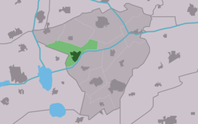
Koatstertille — Kootstertille 53°12′42″N 6°5′39″E / 53.21167, 6.09417 … Wikipédia en Français
Achtkarspelen — Héraldique … Wikipédia en Français
Achtkarspelen — Infobox Settlement official name = Achtkarspelen image seal size = 70px mapsize = 280px subdivision type = Country subdivision name = Netherlands subdivision type1 = Province subdivision name1 = Friesland area footnotes = (2006) area total km2 =… … Wikipedia
List of places in the Netherlands — This is an alphabetical list of places (cities, towns, villages) in the Netherlands. Lists per province can be found at:* List of towns in Groningen * List of towns in Friesland * List of towns in Drente * List of towns in Overijssel * List of… … Wikipedia
Drogeham — Village Flag … Wikipedia
Achtkarspelen — Gemeinde Achtkarspelen Flagge Wappen Provinz Friesland … Deutsch Wikipedia
Augustinusga — 53°13′2″N 6°9′46″E / 53.21722, 6.16278 … Wikipédia en Français
Boelenslaan — 53°9′43″N 6°8′41″E / 53.16194, 6.14472 … Wikipédia en Français
 Pays-Bas