Kapel-Avezaath
Contenu soumis à la licence CC-BY-SA. Source : Article Kapel-Avezaath de Wikipédia en français (auteurs)
Regardez d'autres dictionnaires:
Kapel Avezaath — 51°52′49″N 5°22′45″E / 51.88028, 5.37917 … Wikipédia en Français
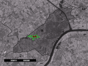
Kapel-Avezaath — Dutch town locator maps mun town caption = The village centre (red) and the statistical district (light green) of Kapel Avezaath in the municipality of Tiel.Kapel Avezaath (coord|51|53|N|5|23|E|type:city(301)) is a village in the Dutch province… … Wikipedia
De Aartkuil — (Kapel Avezaath,Нидерланды) Категория отеля: 3 звездочный отель Адрес: 4016 CT Kapel Ave … Каталог отелей
List of places in the Netherlands — This is an alphabetical list of places (cities, towns, villages) in the Netherlands. Lists per province can be found at:* List of towns in Groningen * List of towns in Friesland * List of towns in Drente * List of towns in Overijssel * List of… … Wikipedia
Liste des localités des Pays-Bas par code postal — Cette page est une liste des localités (villes, villages) des Pays Bas par code postal. Les localités ne possédant pas leur propre code postal ne figurent pas dans cette liste. Sommaire 1 1000 1999 1.1 1000 1099 1.2 1100 1199 … Wikipédia en Français
Tiel — Municipality Flag … Wikipedia
Tiel — Gemeinde Tiel Flagge Wappen Provinz … Deutsch Wikipedia
Bergakker — 51°53′0″N 5°23′0″E / 51.88333, 5.38333 … Wikipédia en Français
Drumpt — 51° 53′ 48″ N 5° 24′ 56″ E / 51.8967, 5.41556 … Wikipédia en Français
Medel (Pays-Bas) — 51°54′0″N 5°27′0″E / 51.9, 5.45 … Wikipédia en Français
 Pays-Bas