Allianoi
- Allianoi
-

Nymphe d'Allianoi, symbole de la sauvegarde du site
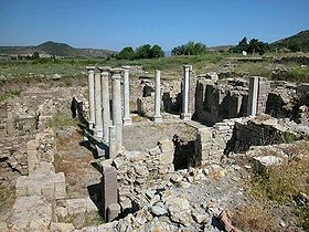
Allianoi est un complexe thermal romain du IIe siècle, situé près de l'actuelle cité de Bergama en Turquie. C'est aujourd'hui une site archéologique majeur, par son étendue et sa richesse, menacé d'immersion par la construction d'un barrage.
Menaces sur le site
Les autorités turques construisent un barrage pour l'irrigation, en amont du site d'Allianoi. Elles prévoient d'engloutir les thermes situés dans la vallée. De nombreux artistes et manifestants réclament l'abandon du projet. Les élus locaux en ont appelé à l'Union européenne et à l'UNESCO pour qu'elles fassent pression sur Ankara. À la fin de l'année 2005, le gouvernement turc avait décidé de suspendre la mise en service du barrage : mais les ruines d'Allianoi sont en sursis.
Bibliographie
- Guillaume Perrier, En Turquie, les thermes d’Allianoi condamnées par un barrage, Le Monde, 25 septembre 2010 (n° 20426), p. 21.
- Conseil international des monutes et sites, Stop the flooding of Allianoi : appeal to save Allianoi (Turkey), 20 mars 2007
Liens externes
Wikimedia Foundation.
2010.
Contenu soumis à la licence CC-BY-SA. Source : Article Allianoi de Wikipédia en français (auteurs)
Regardez d'autres dictionnaires:
Allianoi — is an ancient spa settlement (dating predominantly from the Roman Empire period, 2nd century A.D.) situated near Bergama (ancient Pergamon) in Turkey s İzmir Province. The site is located 18 kilometers to the northeast of Bergama, on the road to… … Wikipedia
Allianoi — Sanatorium von Allianoi mit Innenhof (frühes Ausgrabungsstadium) Quellnymphe Allianoi ( … Deutsch Wikipedia
Bergama — Infobox Settlement settlement type = subdivision type = Country subdivision name = TUR timezone=EET utc offset=+2 map caption =Location of PAGENAME within Turkey. timezone DST=EEST utc offset DST=+3official name = Bergama image caption = Ancient… … Wikipedia
Güneydogu Anadolu Projesi — Karte der Türkei Das Südostanatolien Projekt (GAP, türk. Güneydoğu Anadolu Projesi (GAP)) ist das größte regionale Entwicklungsprojekt der Türkei. Es umfasst insgesamt 22 Staudämme, 19 Wasserkraftwerke und Bewässerungsanlagen entlang der beiden… … Deutsch Wikipedia
Güneydoğu Anadolu Projesi — Karte der Türkei Das Südostanatolien Projekt (GAP, türk. Güneydoğu Anadolu Projesi (GAP)) ist das größte regionale Entwicklungsprojekt der Türkei. Es umfasst insgesamt 22 Staudämme, 19 Wasserkraftwerke und Bewässerungsanlagen entlang der beiden… … Deutsch Wikipedia
Archäologisches Museum Bergama — Statue Hadrians aus der Bibliothek des Asklepieion „Gol … Deutsch Wikipedia
Yortanlı-Talsperre — Bild gesucht BW … Deutsch Wikipedia
Çatalhöyük — (Turkish pronunciation: [tʃaˈtaɫhøjyc]; also Çatal Höyük and Çatal Hüyük, or any of the three without diacritics; çatal is Turkish for fork , höyük for mound ) was a very large Neolithic and Chalcolithic settlement in southern Anatolia,… … Wikipedia
Pergamum — Infobox Settlement official name = Pergamon (Πέργαμος) other name = (Bergama) native name = Ancient Greek City imagesize = 280px image caption = Reconstructed Temple of Trajan at PergamonLocation map Turkey label=Pergamon label size=100… … Wikipedia
Troy — For other uses, see Troy (disambiguation). See also: Troad Coordinates: 39°57′27″N 26°14′20″E / 39.9575°N 26.23889°E … Wikipedia
 Turquie
 Nymphe d'Allianoi, symbole de la sauvegarde du site


