Inverell
- Inverell
-
Wikimedia Foundation.
2010.
Contenu soumis à la licence CC-BY-SA. Source : Article Inverell de Wikipédia en français (auteurs)
Regardez d'autres dictionnaires:
Inverell — Gerichtsgebäude, 1886 erbaut Staat … Deutsch Wikipedia
Inverell — ▪ New South Wales, Australia town, northeastern New South Wales, Australia, at the junction of the Swanbrook and Macintyre rivers in the Western Slopes district. Established in 1848 as a stock station, it was declared a town in 1858 and a… … Universalium
Inverell — Original name in latin Inverell Name in other language IVR, Inverell State code AU Continent/City Australia/Sydney longitude 29.77403 latitude 151.11166 altitude 588 Population 8561 Date 2012 02 28 … Cities with a population over 1000 database
Inverell — /ɪnvəˈrɛl/ (say invuh rel) noun a town in north eastern NSW, on the Macintyre River; mineral resources. In the mid 1830s Scotsmen Peter MacIntyre and Alexander Campbell settled in the New England district on lands traditionally inhabited by the… …
Inverell — Admin ASC 2 Code Orig. name Inverell Country and Admin Code AU.02.14200 AU … World countries Adminstrative division ASC I-II
Inverell, New South Wales — Infobox Australian Place | type = town name = Inverell state = nsw caption = Inverell Court House built in 1886. lga = Inverell Shire Council county = Gough postcode = 2360 est = 1856 pop = 9,749 elevation= 583 maxtemp = 24.0 mintemp = 7.4… … Wikipedia
Inverell Shire — Shire of Inverell Lage des Inverell Shire in New South Wales Gliederung … Deutsch Wikipedia
Inverell Shire Council — Infobox Australian Place | type = lga name = Inverell Shire caption = Location in New South Wales state=New South Wales region=North West Slopes area=8606 est = seat=Inverell (144 Otho Street)cite web title=Inverell Shire Council publisher =… … Wikipedia
Inverell Airport — Infobox Airport name = Inverell Airport nativename = IATA = IVR ICAO = YIVL type = owner = operator = Civil Government city served = location = Inverell, New South Wales, Australia elevation f = 2,667 elevation m = 813 website = metric rwy = Yes… … Wikipedia
Electoral district of Inverell — Inverell was a former electoral district of the Legislative Assembly in the Australian state of New South Wales, created in 1880 and including Inverell. It was abolished in 1904, with the downsizing of the Legislative Assembly after Federation,… … Wikipedia
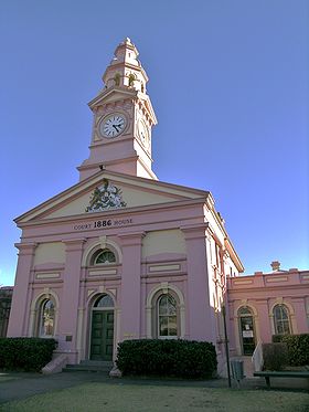 Le palais de justice de Inverell
 Australie
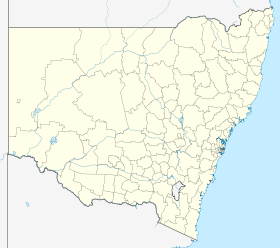
 Inverell


