Holy Loch
- Holy Loch
-
Wikimedia Foundation.
2010.
Contenu soumis à la licence CC-BY-SA. Source : Article Holy Loch de Wikipédia en français (auteurs)
Regardez d'autres dictionnaires:
Holy Loch — a narrow area of the Atlantic Ocean reaching into the land on the west coast of Scotland, northwest of Glasgow. The US Navy formerly had a base there for its nuclear submarines … Dictionary of contemporary English
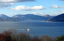
Holy Loch — The Holy Loch (Scottish Gaelic An Loch Sianta/Seunta ) is a sea loch in Argyll and Bute, Scotland. Open to the Firth of Clyde at its eastern end, the loch is approximately one mile wide and between two and three miles (5 km) long, varying with… … Wikipedia
Holy Loch — 55.987 4.933 Koordinaten: 55° 59′ 13″ N, 4° 55′ 59″ W … Deutsch Wikipedia
Holy Loch — geographical name inlet of Firth of Clyde W Scotland on NW shore of the firth opposite mouth of the Clyde … New Collegiate Dictionary
Loch Eck — von Norden Geographische Lage Loch Lomond and the Trossachs National Park, Argyll and Bute, Schottland … Deutsch Wikipedia
Loch Lomond and the Trossachs National Park — Infobox protected area | name = Loch Lomond and The Trossachs National Park iucn category = II caption = Looking eastwards along Loch Katrine in the Loch Lomond and the Trossachs National Park locator x = locator y = location = Scotland, Argyll… … Wikipedia
Loch Maree — Infobox lake lake name = Loch Maree image lake = Loch Maree.jpg caption lake = View of the islands image bathymetry = caption bathymetry = location = Northwest Highlands, Scotland coords = coord|57|41|23|N|5|27|27|W|region:GB… … Wikipedia
Liste schottischer Lochs — Loch ist das schottisch gälische Wort für einen See oder eine Meeresbucht, einen Fjord (englisch Firth). Das Wort, lɔx, «loch» mit kehligem «ch» ausgesprochen, ist verwandt mit dem altirischen Lough, rekonstruierte indogermanische Wurzel… … Deutsch Wikipedia
Dunoon — This article is about the town. For the small town, see Dunoon, New South Wales. Coordinates: 55°56′48″N 4°55′23″W / 55.946730°N 4.923000°W / … Wikipedia
USS Theodore Roosevelt (SSBN-600) — USS Theodore Roosevelt (SSBN 600), a George Washington class submarine, was the second ship of the United States Navy to be named for President Theodore Roosevelt. Initially unnamed and assign hull classification symbol SSGN 600, her keel was… … Wikipedia
 Holy Loch
