Glacier Axel Heiberg
- Glacier Axel Heiberg
-
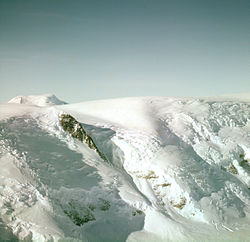
Le glacier Axel Heiberg est un glacier de vallée de 48 km de long, descendant du plateau Antarctique jusqu'à la barrière de Ross entre la chaîne d'Herbert et le mont Don Pedro Christophersen, dans la chaîne de la Reine Maud.
Il fut découvert en novembre 1911 par le capitaine Roald Amundsen qui lui donna le nom du Consul Axel Heiberg, homme d'affaires norvégien et mécène scientifique ayant contribué à de nombreuses expéditions polaires norvégiennes. Amundsen passa par ce glacier pour monter sur le plateau Antarctique et être le premier à atteindre le Pôle Sud.
Voir aussi
Wikimedia Foundation.
2010.
Contenu soumis à la licence CC-BY-SA. Source : Article Glacier Axel Heiberg de Wikipédia en français (auteurs)
Regardez d'autres dictionnaires:
Axel Heiberg — (16 mars 1848 – 4 septembre 1932) était un diplomate, financier et entrepreneur norvégien. Après des études à l étranger, Heiberg occupe le poste de consul de Norvège en Chine. Il revient ensuite en Norvège où il finance la création de la… … Wikipédia en Français
Axel Heiberg Island — Infobox Islands name = Axel Heiberg image caption = Closeup of Axel Heiberg Island image size = locator map custom = native name = native name link = Inuktikut nickname = location = Northern Canada coordinates =… … Wikipedia
Axel Heiberg Glacier — The Axel Heiberg Glacier is a valley glacier, 48 km (30 mi) long, descending from the polar plateau to the Ross Ice Shelf between the Herbert Range and Mount Don Pedro Christophersen, in the Queen Maud Mountains.coord|85|25|S|163|0|W|type:glacier … Wikipedia
Glacier de vallée — Glacier Pour les articles homonymes, voir Glacier (homonymie). Glacier Briksdal, Norvège, 2 juillet 2006 Un glacier … Wikipédia en Français
Glacier de Beardmore — Glacier Beardmore Glacier Beardmore Vue aérienne du glacier Beardmore Latitude Longitude … Wikipédia en Français
Glacier Beardmore — Vue aérienne du glacier Beardmore. Latitude Longitude … Wikipédia en Français
Glacier — Pour les articles homonymes, voir Glacier (homonymie). Le glacier d Aletsch (Suisse), le plus grand glacier des Alpes … Wikipédia en Français
Glacier ice accumulation — occurs through accumulation of snow and other frozen precipitation, as well as through other means including rime ice (freezing of water vapor on the glacier surface), avalanching from hanging glaciers on cliffs and mountainsides above, and re… … Wikipedia
Beardmore Glacier — Glacier Beardmore Glacier Beardmore Vue aérienne du glacier Beardmore Latitude Longitude … Wikipédia en Français
Coronation Glacier — is a glacier on southeastern Baffin Island, Nunavut, Canada. The glacier is on the northeast coast of Cumberland Peninsula and is an outlet glacier of the Penny Ice Cap. The Coronation Glacier lost its connection to the Elena Glacier between 1943 … Wikipedia
 Antarctique