Gasselternijveenschemond

Gasselternijveenschemond

52°59′44″N 6°53′50″E / 52.99556, 6.89722

Gasselternijveenschemond
Administration
Pays Drapeau : Pays-Bas Pays-Bas
Province Drenthe
Commune Aa en Hunze
Géographie
Population 745 hab. (2008)
Autres informations
Code postal 9515
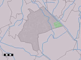
Localisation de Gasselternijveenschemond dans la commune de Aa en Hunze

Gasselternijveenschemond est un village dans la commune néerlandaise d'Aa en Hunze, dans la province de Drenthe. Le 1er janvier 2008, le village comptait 745 habitants.

C'est un village-rue, le long d'un des multiples canaux (mond) dans les anciennes tourbières exploitées et défrichées de l'est de Drenthe.

Hameaux

Les hameaux de Gasselterboerveenschemond, Eerste Dwarsdiep et Tweede Dwarsdiep dépendent de ce village.


Wikimedia Foundation. 2010.

Contenu soumis à la licence CC-BY-SA. Source : Article Gasselternijveenschemond de Wikipédia en français (auteurs)

Игры ⚽ Поможем написать реферат

Regardez d'autres dictionnaires:

  • Gasselternijveenschemond — Dutch town locator maps mun town caption = Gasselternijveenschemond in the municipality of Aa en Hunze.Gasselternijveenschemond (coord|53|0|N|6|54|E|type:city(710)) is a town in the Dutch province of Drenthe. It is a part of the municipality of… …   Wikipedia

  • Gasselternijveenschemond Tweede Dwarsdiep — 52°59′59″N 6°53′39″E / 52.99972, 6.89417 …   Wikipédia en Français

  • Gasselternijveenschemond Eerste Dwarsdiep — 53°0′0″N 6°55′22″E / 53, 6.92278 …   Wikipédia en Français

  • Aa En Hunze — Pour les articles homonymes, voir Aa. Aa en Hunze …   Wikipédia en Français

  • Aa en Hunze — Pour les articles homonymes, voir Aa. Aa en Hunze …   Wikipédia en Français

  • Aa en hunze — Pour les articles homonymes, voir Aa. Aa en Hunze …   Wikipédia en Français

  • Aa en Hunze — Infobox Settlement official name = Aa en Hunze mapsize = 280px subdivision type = Country subdivision name = Netherlands subdivision type1 = Province subdivision name1 = Drenthe area footnotes = (2006) area total km2 = 278.86 area land km2 =… …   Wikipedia

  • List of cities, towns and villages in Drenthe — This is a list of settlements in the province of Drenthe, in the Netherlands. Name Municipality Coordinates Aalden Coevorden …   Wikipedia

  • Schreierswijk — 52°59′6″N 6°51′23″E / 52.985, 6.85639 …   Wikipédia en Français

  • Nieuw-Annerveen —   Town   …   Wikipedia

Share the article and excerpts

Direct link
Do a right-click on the link above
and select “Copy Link”