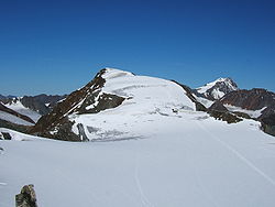
Fluchtkogel
- Fluchtkogel
-
Le Fluchtkogel est un sommet des Alpes, à 3 497 m d'altitude, dans le massif de l'Ötztal, en Autriche (Tyrol).
Catégories :
- Sommet des Alpes autrichiennes
- Montagne du Tyrol
Wikimedia Foundation.
2010.
Contenu soumis à la licence CC-BY-SA. Source : Article Fluchtkogel de Wikipédia en français (auteurs)
Regardez d'autres dictionnaires:
Fluchtkogel — von Südwesten, von der Dahmann Spitze Höhe 3.497 … Deutsch Wikipedia
Kesselwandspitze — pd1 Kesselwandspitze Kesselwandspitze von Nordnordwest, beim Abstieg vom Fluchtkogel … Deutsch Wikipedia
Hauslabjoch — f1 Ötztaler Alpen Lage der Ötztaler Alpen innerhalb der Ostalpen Höchster Gipfel Wildspitze (3.768 … Deutsch Wikipedia
Hochvernagtspitze — pd1 Hochvernagtspitze Hochvernagtspitze von Süden, vom Fluchtkogel Höhe … Deutsch Wikipedia
Vernagt-Hütte — Vernagthütte DAV Hütte Kategorie I Vernagthütte mit Hintergrasleck Lage hinteres Rofental im Weißkamm; … Deutsch Wikipedia
Weißkamm — Gepatschferner und Weißkugel, vorn das Brandenburger Haus Der stark vergletscherte Weißkamm trägt mit Weißkugel (3.739 m ü. A.) und Wildspitze (3.772 … Deutsch Wikipedia
Hochvernagtspitze — depuis le Fluchtkogel au sud Géographie Altitude 3 539 m Massif Alpes de l Ötztal … Wikipédia en Français
Geography of Austria — Continent Europe Region Central Europe Coordinates … Wikipedia
Brandenburger Haus — DAV Hütte Kategorie I Lage zwischen Gepatsch und Kesselwandferner; Bundesland … Deutsch Wikipedia
Geographie Österreichs — Die Lage Österreichs, in der europäischen Union, Europa und der Welt Geographie Österreichs Inhaltsverzeichnis 1 … Deutsch Wikipedia
 Autriche