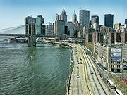
FDR Drive
- FDR Drive
-
Franklin D. Roosevelt Driveway
Franklin D. Roosevelt Driveway est une voie rapide de 15 kilomètres longeant l'East River, sur le côté est de Manhattan, à New York. Accessible toutes les 10 à 20 rues, elle est l'équivalent de l'Henry Hudson Parkway, construite sur le bord ouest de l'île.
 Portail de New York
Catégorie : Rue de New York
Wikimedia Foundation.
2010.
Contenu soumis à la licence CC-BY-SA. Source : Article FDR Drive de Wikipédia en français (auteurs)
Regardez d'autres dictionnaires:
FDR (disambiguation) — FDR may refer to:* Franklin Delano Roosevelt, the 32nd President of the United States * Franklin Delano Roosevelt Lake, the reservoir created by the Grand Coulee Dam * Franklin Delano Roosevelt, III (1938 ), American economist * Full Depth… … Wikipedia
Franklin D. Roosevelt East River Drive — Route information Maintained by NYSDOT and NYCDOT Length … Wikipedia
Harlem River Drive — Route information Length: 4.20 mi[1] (6.76 km) … Wikipedia
Harlem River Drive — Harlem River … Wikipedia Español
Morningside Drive (Manhattan) — Columbia University buildings across Morningside Drive, seen from a scenic overlook within Morningside Park … Wikipedia
List of streets in Manhattan — This article covers numbered east west streets in Manhattan, New York City. Major streets have their own linked articles; minor streets are discussed here. The streets do not run exactly east west, because their grid is aligned with the Hudson… … Wikipedia
List of bus routes in Manhattan — An M15 SBS bus at James Street The Metropolitan Transportation Authority operates a number of bus routes in Manhattan, New York, United States. Many of them are the direct descendants of streetcar lines (see list of streetcar lines in Manhattan) … Wikipedia
New York State Route 9A — NYS Route 9A Map of the New York City area with NY 9A highlighted in red … Wikipedia
Liste der Viertel Manhattans — Überblick über die Lage der Viertel Manhattans Diese Liste der Viertel (englisch Neighborhoods) im New Yorker Stadtbezirk Manhattan ist geographisch geordnet: vom Norden der Insel zum Süden. Manhattan teilt sich in folgende Gebiete auf:… … Deutsch Wikipedia
Cherry Street (Manhattan) — East end of Cherry Street at Vladeck Houses and Corlear s Hook Park … Wikipedia
 Le pont de Brooklyn au-dessus de la FDR Driveway en 2004.
