Emerald Bay State Park
- Emerald Bay State Park
-
Parc d'État d'Emerald Bay
Le Parc d'État d'Emerald Bay (en anglais : Emerald Bay State Park) est une réserve naturelle située dans l'État de Californie, à l’ouest des États-Unis. Il se trouve près du lac Tahoe et devint National Natural Landmark en 1969.
Voir aussi
Lien interne
Lien externe
 Portail de la conservation de la nature
 Portail de la Californie
Catégorie : Parc d'État de la Californie
Wikimedia Foundation.
2010.
Contenu soumis à la licence CC-BY-SA. Source : Article Emerald Bay State Park de Wikipédia en français (auteurs)
Regardez d'autres dictionnaires:
Emerald Bay State Park — Infobox protected area | name = Emerald Bay State Park iucn category = caption = Emerald Bay, with Fannette Island locator x = locator y = location = Lake Tahoe, California, USA nearest city = South Lake Tahoe lat degrees = 38 lat minutes = 57… … Wikipedia
Emerald Bay State Park — Die Emerald Bay mit Lake Tahoe im Hintergrund Der Emerald Bay State Park liegt in der Sierra Nevada im Nordosten des US Bundesstaats Kalifornien. Zentrum des Parks ist die Emerald Bay (zu deutsch Smaragdbucht), die im Nordosten mit dem Lake Tahoe … Deutsch Wikipedia
Morro Bay State Park — Black Hill Morro Bay State Park is a state park in Morro Bay, in western San Luis Obispo County, California. On the bay’s northeastern edge, there is a saltwater marsh that supports a thriving bird population. [1] … Wikipedia
Maumee Bay State Park — Type State park Location Jerusalem Township, Ohio Created … Wikipedia
Parc d'Etat d'Emerald Bay — Parc d État d Emerald Bay Emerald Bay, Lac Tahoe Le Parc d État d Emerald Bay (en anglais : Emerald Bay State Park) est une réserve naturelle située dans l État de Californie, à l’ouest des États Unis. Il se trouve près du lac Tahoe et… … Wikipédia en Français
Parc d'État d'Emerald Bay — 38° 57′ 13″ N 120° 05′ 38″ W / 38.9536, 120.094 … Wikipédia en Français
Cuyamaca Rancho State Park — Further information: Rancho Cuyamaca Cuyamaca Rancho State Park West Mesa Trail in the Laguna Mountains, Cuyamaca Rancho State Park. Location … Wikipedia
Malibu Creek State Park — Malibu Creek State Park, with the Goat Buttes in the background. Coordinates … Wikipedia
Chino Hills State Park — Coordinates: 33°57′16″N 117°42′07″W / 33.954325°N 117.701855°W / 33.954325; 117.701855 … Wikipedia
Crystal Cove State Park — Location Orange County, California Nearest city Newport Beach[1] … Wikipedia
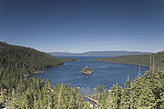 Emerald Bay, Lac Tahoe
