Ekhtiarieh
- Ekhtiarieh
-
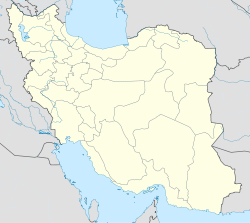
Ekhtiarieh est un quartier au nord de Téhéran dans le district de Gheytarieh.
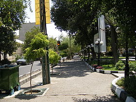
Dibaji est une banlieue et consiste majoritairement en des maisons modestes, des appartements aussi bien que des boutiques éparses. En contraste avec plusieurs des districts chics et flashy qui l'entourrent (comme Farmanieh et Shemiran), Dibaji est connu pour être modeste et religieux.
La zone est centrée autour du parc Dibaji, et le district est généralement considéré comme l'une des zones de Téhéran les plus vertes et les plus sûres.
Histoire
En 1970, la plupart de Dibaji a été construite et en 1990 l'autoroute Sadr fut construit le long de sa limite nord en développement.
Liens internes
Wikimedia Foundation.
2010.
Contenu soumis à la licence CC-BY-SA. Source : Article Ekhtiarieh de Wikipédia en français (auteurs)
Regardez d'autres dictionnaires:
Ekhtiarieh — Dibaji Park along Dibaji Street Ekhtiarieh (Dibaji) is a district in northern Tehran, Iran. Often referred to as Ekhtiyarieh or South Dibaji, Dibaji is located mainly along Dibaji Street and refers to the areas surrounding the street south from… … Wikipedia
Dibaji — Ekhtiarieh Ekhtiarieh Le parc Dibaji le long de la rue du même nom Administration Conseil de quartier District n°3 Géographie … Wikipédia en Français
Ekhtiyarieh — Ekhtiarieh Ekhtiarieh Le parc Dibaji le long de la rue du même nom Administration Conseil de quartier District n°3 Géographie … Wikipédia en Français
Doulat — (also spelled Dowlat) is a district in northern Tehran, Iran. Doulat is mostly suburban in nature and is located between Shariati street and Pasdaran street. It neighbors Daroos, Dibaji, Ekhtiarieh districts. Many shops and restaurants are… … Wikipedia
Tehran — This article is about the Iranian capital city. For other uses, see Tehran (disambiguation). Tehran تهران … Wikipedia
Darband, Tehran — The foot of Darband s popular hiking trail in Tehran … Wikipedia
Niavaran — The Niavaran branch of the National Library of Iran offers a pleasant environment for its users … Wikipedia
Mahmoodieh — or Mahmoodiyeh is an affluent residential area in Tehran, located south of Zaferaniyeh, bordering Valiasr Avenue on the east side, Velenjak on the west, and Chamran expressway to the south. The area is in close proximity to Tajrish. Mahmoodieh… … Wikipedia
Narmak — File:Narmak in Tehran.PNG Location of Narmak (black) in Municipal District No. 8 (dark grey area on the map) of Tehran metropolis Narmak is a neighbourhood in north east Tehran, the capital city of Iran. Narmak is the largest neighborhood in… … Wikipedia
Nazi Abad — is a neighborhood to the south of the central district of the city of Tehran in Iran. Although the south part of Tehran is poorer than the north part, Nazi Abad is one of the best neighborhoods.High crime rate and over population is the feature… … Wikipedia