East Glacier Park Village (Montana)

East Glacier Park Village (Montana)

48° 26′ 38″ N 113° 13′ 18″ W / 48.443889, -113.221667

East Glacier Park Village
Administration
Pays Drapeau des États-Unis États-Unis
État Montana Montana
Comté Glacier
Démographie
Population (2000) 396 hab.
Densité 35 hab./km²
Géographie
Coordonnées 48° 26′ 38″ Nord
       113° 13′ 18″ Ouest
/ 48.443889, -113.221667
Superficie totale 11,3 km2
· dont terre 11,3 km2 (100 %)
· dont eau 0 km2 (0 %)
Fuseau horaire MST (UTC-7)
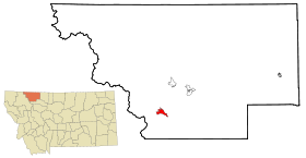
Voir la carte administrative
City locator 14.svg
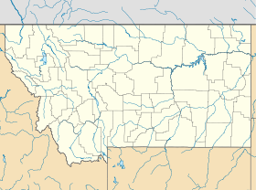
Voir la carte topographique
City locator 14.svg

East Glacier Park Village est un village situé dans le comté de Glacier dans le Montana aux États-Unis. La population était de 396 individus lors du recensement de 2000.

Géographie

Le village se situe à l'est du parc national de Glacier. La superficie est de 11,3 km² et est composée exclusivement de terres. Une gare située le long de ligne de chemin de fer BNSF se trouve dans le village.

Démographie

Selon le recensement de 2000, sur les 396 habitants, on retrouvait 148 ménages et 101 familles. La densité de population était de 35 habitants par km² et la densité d’habitations (76.230 au total) était de 19 habitations par km². La population était composée de 51,75% d’amérindiens, de 43,43% de blancs et de 0,25% d’afro-américains.

32,10% des ménages avaient des enfants de moins de 18 ans, 50,7% étaient des couples mariés. 25,8% de la population avait moins de 18 ans, 5,6% entre 18 et 24 ans, 28,8% entre 25 et 44 ans, 26,5% entre 45 et 64 ans et 7,1% au-dessus de 65 ans. L’âge moyen était de 36 ans. La proportion de femmes était de 100 pour 92,1 hommes.

Le revenu moyen d’un ménage était de 37.417 dollars.

Liens externes


Wikimedia Foundation. 2010.

Contenu soumis à la licence CC-BY-SA. Source : Article East Glacier Park Village (Montana) de Wikipédia en français (auteurs)

Игры ⚽ Поможем решить контрольную работу

Regardez d'autres dictionnaires:

  • East Glacier Park Village, Montana — Infobox Settlement official name = East Glacier Park, Montana settlement type = CDP nickname = motto = imagesize = image caption = image imagesize = image caption = image mapsize = 250px map caption = Location of East Glacier Park, Montana… …   Wikipedia

  • East Glacier Park Village — East Glacier Park Village, MT U.S. Census Designated Place in Montana Population (2000): 396 Housing Units (2000): 219 Land area (2000): 4.356123 sq. miles (11.282306 sq. km) Water area (2000): 0.000000 sq. miles (0.000000 sq. km) Total area… …   StarDict's U.S. Gazetteer Places

  • East Glacier Park Village, MT — U.S. Census Designated Place in Montana Population (2000): 396 Housing Units (2000): 219 Land area (2000): 4.356123 sq. miles (11.282306 sq. km) Water area (2000): 0.000000 sq. miles (0.000000 sq. km) Total area (2000): 4.356123 sq. miles… …   StarDict's U.S. Gazetteer Places

  • Glacier Park Lodge — is located just outside the boundaries of Glacier National Park in the village of East Glacier Park, Montana, United States. The lodge was built in 1913 by the Glacier Park Company, a subsidiary of the Great Northern Railway. Glacier Park Lodge… …   Wikipedia

  • Glacier Park Lodge — 48°26′43″N 113°13′23″O / 48.44528, 113.22306 …   Wikipédia en Français

  • Montana locations by per capita income — Montana is the forty sixth richest state in the United States of America, with a per capita income of $17,151 (2000). Montana counties ranked by per capita income There are fifty six counties located in Montana, none of which are in the 100… …   Wikipedia

  • Glacier County — Verwaltung US Bundesstaat: Montana Verwaltungssitz: Cut Bank Gründung: 1919 Demographie Einwohner: 13.247  (2000) …   Deutsch Wikipedia

  • Glacier County, Montana — Infobox U.S. County county= Glacier County state= Montana map size= 225 founded=1919 seat= Cut Bank largest city= Cut Bank leader= area total sq mi=3037 area land sq mi=2995 area water sq mi=42 area percentage= 1.40% census yr= 2000 pop= 13247… …   Wikipedia

  • National Register of Historic Places listings in Glacier County, Montana — Location of Glacier County in Montana This is a list of the National Register of Historic Places listings in Glacier County, Montana. It is intended to be a complete list of the properties and districts on the National Register of Historic Places …   Wikipedia

  • Cut Bank, Montana — See also: Cut Bank Creek and Cut bank Cut Bank, Montana   City   La …   Wikipedia

Share the article and excerpts

Direct link
Do a right-click on the link above
and select “Copy Link”