Driemond
- Driemond
-
52° 18′ 00″ N 5° 01′ 00″ E / 52.3, 5.01667
 |
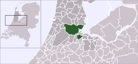
| Situation de Driemond dans la commune d'Amsterdam (centre ville en vert foncé et district statistique en vert clair). |
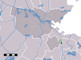
Driemond est un village de la province de Hollande-Septentrionale aux Pays-Bas. Elle fait partie de la commune de Amsterdam.
Le district statistique compte environ 1500 habitants dont 1422 pour la ville elle-même (2005).
Avant 1966, Driemond faisait partie de la commune de Weesperkarspel. Le nom de Driemond signifie « trois embouchures » et fait allusion aux trois rivières Gein, Gaasp et Smalle Weesp qui se rejoignent dans la ville.
Wikimedia Foundation.
2010.
Contenu soumis à la licence CC-BY-SA. Source : Article Driemond de Wikipédia en français (auteurs)
Regardez d'autres dictionnaires:
Driemond — Town … Wikipedia
Driemond — Original name in latin Driemond Name in other language State code NL Continent/City Europe/Amsterdam longitude 52.30583 latitude 5.01667 altitude 1 Population 1500 Date 2009 01 15 … Cities with a population over 1000 database
Stadtteile von Amsterdam — Die Stadtteile von Amsterdam haben sich mit der neuen Einteilung der Stadtbezirke von Amsterdam (Mai 2010) ebenfalls geändert. Die heutigen sieben Stadtbezirke der Gemeinde Amsterdam (ohne das Gewerbegebiet Westpoort) sind aufgeteilt in 97… … Deutsch Wikipedia
Kinderdijk — Coordinates: 51°53′N 4°38′E / 51.883°N 4.633°E / 51.883; 4.633 … Wikipedia
De Adriaan, Haarlem — Windmill De Adriaan De Adriaan is a windmill in the Netherlands that burnt down in 1932 and was rebuilt in 2002. The original windmill dates from 1779 and the mill has been a distinctive part of the skyline of Haarlem for centuries. Contents … Wikipedia
Government of Amsterdam — The Government of Amsterdam is the government of the municipality and city of Amsterdam in the Netherlands. Most of the inhabitants live in the city of Amsterdam, but the municipality also covers a number of small villages, and other parts of the … Wikipedia
Amsterdam Zuidoost — is one of the 15 boroughs (stadsdelen) of the city of Amsterdam, that consists of four residential areas Bijlmermeer, Venserpolder, Gaasperdam and the village Driemond, as well as a business park Amstel III/Bullewijk which includes the… … Wikipedia
Bijlmermeer — The Bijlmermeer (pronounced|bɛilməʁmeːʁ) or colloquially Bijlmer (IPA| [bɛilməʁ] ) is one of the neighborhoods that form the Amsterdam Zuidoost ( Amsterdam South East ) borough (or stadsdeel ) of Amsterdam, the Netherlands. To many people, the… … Wikipedia
History of Amsterdam — Amsterdam has a short and eventful history. The origins of the city lie in the 13th century, when fisherman living along the banks of the River Amstel built a bridge across the waterway near the IJ, then a large saltwater inlet. Wooden doors on… … Wikipedia
Nieuwmarkt — Formerly a gate and weighing house,The Waag currently houses a cafe/restaurant … Wikipedia

