Doi Inthanon

Doi Inthanon
Doi Inthanon
Doi Inthanon Thailand 2005.jpg
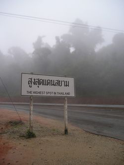
Géographie
Altitude 2 565 m
Massif Shan Hills (Himalaya)
Coordonnées 18° 35′ 32″ Nord
       98° 29′ 12″ Est
/ 18.59222, 98.48667
18°35′32″N 98°29′12″E / 18.59222, 98.48667
Administration
Pays Drapeau de Thaïlande Thaïlande
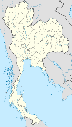
Province Chiang Mai
Amphoe Mae Chaem, Chom Thong, Mae Wang
Ascension
Voie la plus facile Route versant sud

Géolocalisation sur la carte : Thaïlande

(Voir situation sur carte : Thaïlande)
Doi Inthanon

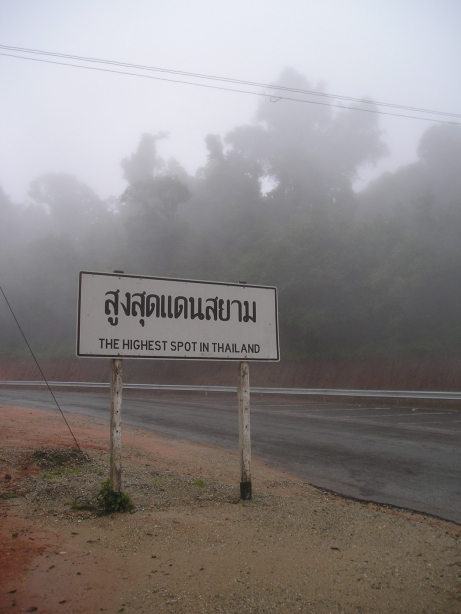
Le Doi Inthanon (en thaï : ดอยอินทนนท์), est le plus haut sommet de Thaïlande, avec 2 565 mètres. Situé dans la province de Chiang Mai, au nord du pays, c'est une destination touristique internationale. L'ancien nom est « Doi Luang ». Le mot thaï luang veut dire « grand ».

Le climat y ressemble plus à celui de l’Europe nordique qu'à celui de la Thaïlande. Il fait frais et humide tout au long de l’année et il gèle sur le sommet en hiver.

Le Doi Inthanon est la source de nombreux cours d'eau faisant partie du bassin versant de la Mae Ping (tributaire de la Chao Phraya). Les pins et les tecks sont très abondants dans les forêts de la montagne.

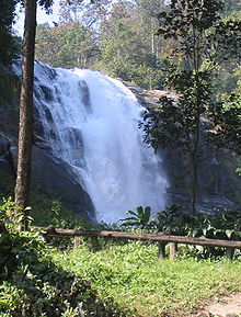
Une des cascades du Parc National

Le parc national de Doi Inthanon (482 km2) est probablement l'écosystème ouvert au tourisme le mieux préservé de la Thaïlande. Ses paysages, où rivières et animaux abondent, sont exceptionnels, avec plusieurs chutes d’eau attrayantes, en particulier celle de la Mae Ya. On y trouve les roses sauvages qui ressemblent à celles des Phu Kradueng, la montagne au nord-est de la Thaïlande, mais qui y sont beaucoup plus grandes, notamment les « roses de mille-années ».

Lien externe


Wikimedia Foundation. 2010.

Contenu soumis à la licence CC-BY-SA. Source : Article Doi Inthanon de Wikipédia en français (auteurs)

Игры ⚽ Нужно решить контрольную?

Regardez d'autres dictionnaires:

  • Doi Inthanon — Napapon Phoom siri Chedi dedicated to the Queen of Thailand commemorating her 60th birthday in 1992) near the summit of Doi Inthanon Elevation …   Wikipedia

  • Doi Inthanon — ดอยอินทนนท์ / Doi Inthanon Phra Mahathat Napapon Phumsiri Chedi erinnert an den 60. Geburtstag von Königin Sirikit Höhe …   Deutsch Wikipedia

  • Doi Inthanon National Park — The Wachirathan waterfall within the national park, on Doi Inthanon, the highest mountain in Thailand …   Wikipedia

  • Nationalpark Doi Inthanon — Wachirathan Wasserfall …   Deutsch Wikipedia

  • Doi Suthep (Berg) — Doi Suthep Bild gesucht  BWf1 Höhe 1.676  …   Deutsch Wikipedia

  • Doi Phu Kha National Park — IUCN Category II (National Park) Location Thailand Nearest city …   Wikipedia

  • Doi Khuntan National Park — (Thai: อุทยานแห่งชาติดอยขุนตาล) is located in Lamphun and Lampang Provinces, in northern Thailand. Established in 1975, it is an IUCN Category V protected area measuring 255.29 square kilometres (98.57 sq mi).[1] References ^ World… …   Wikipedia

  • Doi Suthep — Panoramic view of Doi Suthep as seen from Chiang Mai Doi Suthep …   Wikipedia

  • Inthanon, Mount — ▪ mountain, Thailand Thai  Doi Inthanon        mountain in northwestern Thailand that is the country s highest peak (8,481 feet [2,585 m]). It lies southwest of Chiang Mai, in a spur of the Danen Range between the Chaem (west) and Ping (east)… …   Universalium

  • Doi Suthep-Pui National Park — Road within the park. Doi Suthep Pui National Park (Thai: อุทยานแห่งชาติดอยสุเทพ ปุย) is located in Chiang Mai Province, in northern Thailand. Established in 1981, it is an IUCN Category II protected area measuring 261.06 square kilometres… …   Wikipedia

Share the article and excerpts

Direct link
Do a right-click on the link above
and select “Copy Link”