District de radkersburg
- District de radkersburg
-
District de Radkersburg
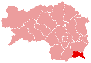
Le district de Radkersburg est une subdivision territoriale du land de Styrie en Autriche.
Géographie
Relief
Lieux administratifs voisins
Économie et infrastructures
Communes
Le district de Radkersburg est subdivisé en 19 communes :
- Bad Radkersburg
- Bierbaum am Auersbach
- Deutsch Goritz
- Dietersdorf am Gnasbach
- Eichfeld
- Gosdorf
- Halbenrain
- Hof bei Straden
- Klöch
- Mettersdorf am Sassbach
- Mureck
- Murfeld
- Radkersburg Umgebung
- Ratschendorf
- Sankt Peter am Ottersbach
- Straden
- Tieschen
- Trössing
- Weinburg am Sassbach
 Portail de l’Autriche
Catégories : District d'Autriche | Styrie
Wikimedia Foundation.
2010.
Contenu soumis à la licence CC-BY-SA. Source : Article District de radkersburg de Wikipédia en français (auteurs)
Regardez d'autres dictionnaires:
District De Radkersburg — Radkersburg Informations Pays Autriche … Wikipédia en Français
District de Radkersburg — Radkersburg Localisation du Bezirk de Radkersburg dans le Land autrichien de Styrie Informations Pays … Wikipédia en Français
Radkersburg Umgebung — Blason inconnu … Wikipédia en Français
District De Feldbach — Feldbach Informations Pays Autriche … Wikipédia en Français
District de feldbach — Feldbach Informations Pays Autriche … Wikipédia en Français
District De Leibnitz — Leibnitz Informations Pays Autriche … Wikipédia en Français
District de leibnitz — Leibnitz Informations Pays Autriche … Wikipédia en Français
Radkersburg Umgebung — Infobox Ort in Österreich Art = Gemeinde Name = Radkersburg Umgebung Wappen = lat deg = 46 | lat min = 42 | lat sec = 10 lon deg = 15 | lon min = 59 | lon sec = 52 Lageplan = Bundesland = Steiermark Bezirk = Radkersburg Höhe = 210 Fläche = 27.76… … Wikipedia
District de Feldbach — Feldbach Localisation du Bezirk de Feldbach dans le Land autrichien de Styrie Informations Pays … Wikipédia en Français
District de Leibnitz — Leibnitz Localisation du Bezirk de Leibnitz dans le Land autrichien de Styrie Informations Pays … Wikipédia en Français

 Autriche
 Styrie
